Edati | |
|---|---|
 Edati Location in Nigeria | |
| Coordinates: 9°03′N 5°39′E / 9.050°N 5.650°E | |
| Country | |
| State | Niger State |
| Government | |
| • Local Government Chairman and the Head of the Local Government Council | Isah Liman Kantigi |
| Area | |
| • Total | 1,752 km2 (676 sq mi) |
| Population (2006 census) | |
| • Total | 160,321 |
| Time zone | UTC+1 (WAT) |
| 3-digit postal code prefix | 912 |
| ISO 3166 code | NG.NI.ED |
Edati is a Local Government Area in Niger State, Nigeria. Its headquarters are in the town of Enagi in the west of the area on the A124 highway at 9°08′00″N 5°33′00″E / 9.13333°N 5.55000°E. The LGA consists of two areas, separated by the Kaduna River. It has an area of 1,752 km2 and a population of 160,321 at the 2006 census.
The postal code of the area is 913.[1]
References
- ↑ "Post Offices- with map of LGA". NIPOST. Archived from the original on 2009-10-07. Retrieved 2009-10-20.
State capital: Minna | ||
| Local Government Areas | 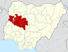 | |
This article is issued from Wikipedia. The text is licensed under Creative Commons - Attribution - Sharealike. Additional terms may apply for the media files.