| Eaton Northern Territory | |||||||||||||||
|---|---|---|---|---|---|---|---|---|---|---|---|---|---|---|---|
 Darwin Airport flight control tower | |||||||||||||||
 Eaton | |||||||||||||||
| Coordinates | 12°24′39″S 130°52′56″E / 12.4108°S 130.8823°E[1] | ||||||||||||||
| Population | 213 (2016 census)[2] | ||||||||||||||
| Established | 4 April 2007[1] | ||||||||||||||
| Postcode(s) | 0820[3] | ||||||||||||||
| Time zone | ACST (UTC+9:30) | ||||||||||||||
| LGA(s) | City of Darwin[1] | ||||||||||||||
| Territory electorate(s) | Spillett[4] | ||||||||||||||
| Federal division(s) | Solomon[5] | ||||||||||||||
| |||||||||||||||
| |||||||||||||||
| Footnotes | Adjoining suburbs[7] | ||||||||||||||
Eaton is a suburb in the Northern Territory of Australia located in the city of Darwin.[5][1] It is the traditional country and waterways of the Larrakia people.[8]
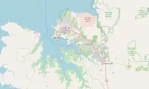
It consists of the land occupied by the Darwin International Airport and RAAF Base Darwin.[1]
Eaton is named in commemoration of Charles Eaton (1895 - 1979), a senior officer in the Royal Australian Air Force whose service included appointment as the "Station Commander of RAAF Darwin" in 1940. The suburb’s boundary and name were gazetted on 4 April 2007.[1]
The 2016 Australian census which was conducted in August 2016 reports that Eaton had 213 people living within its boundaries.[2]
Eaton is located within the federal division of Solomon, the territory electoral division of Spillett and the municipality of the City of Darwin.[5][1][4]
References
- 1 2 3 4 5 6 7 "Search results for 'Eaton (Suburb)'". NT Place Names Register. Northern Territory Government. Retrieved 22 February 2019.
- 1 2 Australian Bureau of Statistics (27 June 2017). "Eaton (NT) (State Suburb)". 2016 Census QuickStats. Retrieved 22 February 2019.
- ↑ "Eaton Postcode (NT)". whatpostcode.com.au. Retrieved 22 February 2019.
- 1 2 "Division of Spillett". Northern Territory Electoral Commission SA. Retrieved 22 February 2019.
- 1 2 3 "Federal electoral division of Solomon". Australian Electoral Commission. Retrieved 22 February 2019.
- 1 2 3 "Monthly climate statistics: Summary statistics DARWIN AIRPORT (nearest weather station)". Commonwealth of Australia , Bureau of Meteorology. Retrieved 22 February 2019.
- ↑ Chumwa, User. "File:Map of the Wards and Suburbs of Darwin, Northern Territory.png". Wikimedia Commons. Retrieved 22 February 2019.
{{cite web}}:|first1=has generic name (help) - ↑ "The Larrakia People". Larrakia Nation. 31 March 2023. Retrieved 1 December 2023.