East Kotawaringin Regency
Kabupaten Kotawaringin Timur | |
|---|---|
 Coat of arms | |
| Motto(s): "Habaring Hurung" Ngaju language: "Mutual Cooperation and Assistance" | |
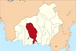 Location within Central Kalimantan | |
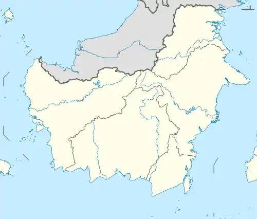 East Kotawaringin Regency Location in Kalimantan and Indonesia 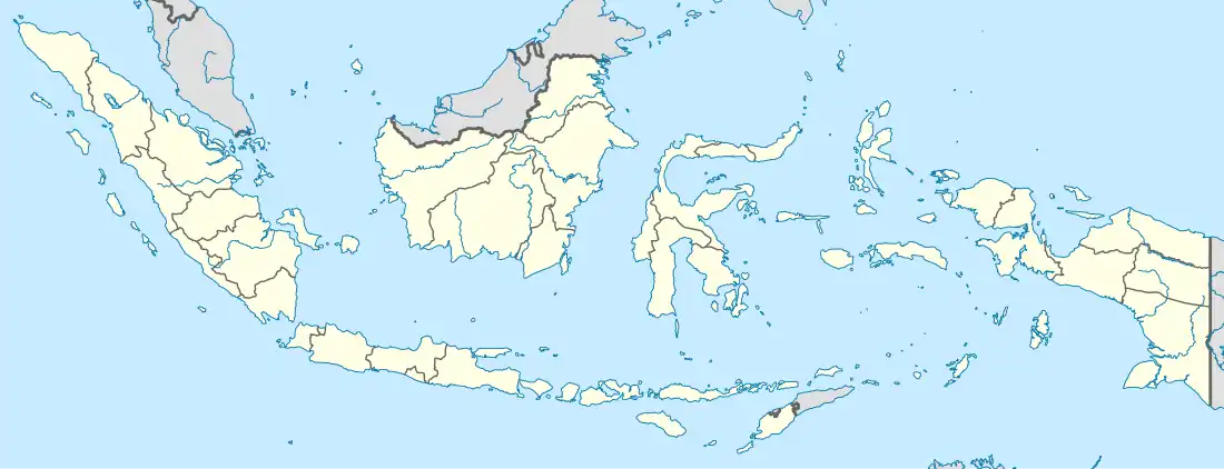 East Kotawaringin Regency East Kotawaringin Regency (Indonesia) | |
| Coordinates: 2°05′00″S 112°45′00″E / 2.0833°S 112.7500°E | |
| Country | Indonesia |
| Region | Kalimantan |
| Province | Central Kalimantan |
| Capital | Sampit |
| Government | |
| • Regent | Halikinnor |
| • Vice Regent | Irawati |
| Area | |
| • Total | 6,485 sq mi (16,796 km2) |
| Population (mid 2022 estimate) | |
| • Total | 436,079 |
| • Density | 67/sq mi (26/km2) |
| [1] | |
| Time zone | UTC+7 (Western Indonesia Time) |
| Area code | (+62) 531 |
| Website | kotimkab |
East Kotawaringin Regency (Indonesian: Kabupaten Kotawaringin Timur) is one of the thirteen regencies which comprise the Central Kalimantan Province on the island of Kalimantan (Borneo), Indonesia. It originally covered a much larger part of the province, but on 10 April 2002 several districts in the west of the regency were split off to form the new Seruyan Regency, and several districts in the east of the regency were similarly split off to form the new Katingan Regency. The population of the residual East Kotawaringin Regency was 374,175 at the 2010 Census,[2] and 428,900 at the 2020 Census;[3] the official estimate as at mid 2022 was 436,079 (comprising 224,238 males and 211,841 females).[1] The town of Sampit is the capital of East Kotawaringin Regency.
Administrative Districts
At the 2010 Census, East Kotawaringin Regency consisted of fifteen districts (kecamatan), but two more districts (Tualan Hulu and Telaga Antang) were subsequently established by the splitting of existing districts. The seventeen districts are tabulated below with their areas and population totals from the 2010 Census[2] and the 2020 Census,[3] together with the official estimates as at mid 2022.[1] The table also includes the locations of the district administrative centres, the number of administrative villages in each district (totaling 168 rural desa and 17 urban kelurahan), and its postal codes.
| Kode Wilayah | Name of District (kecamatan) | Area in km2 | Pop'n Census 2010 | Pop'n Census 2020 | Pop'n Estimate mid 2021 | Admin centre | No. of villages | Post codes |
|---|---|---|---|---|---|---|---|---|
| 62.02.08 | Mentaya Hilir Selatan (South Lower Mentaya) | 318.00 | 20,801 | 23,000 | 23,091 | Samuda | 10 (a) | 74363 |
| 62.02.11 | Teluk Sampit (Sampit Bay) | 610.00 | 8,935 | 10,600 | 10,736 | Ujung Pandaran | 6 | 74364 |
| 62.02.09 | Pulau Hanaut (Hanaut Island) | 620.00 | 15,473 | 16,800 | 16,809 | Bapinang | 14 | 74362 |
| 62.02.06 | Mentawa Baru Ketapang | 726.00 | 76,951 | 98,700 | 101,901 | Sampit | 11 (b) | 74321 - 76326 |
| 62.02.12 | Seranau | 548.00 | 9,587 | 10,900 | 10,965 | Mentaya Seberang | 6 (c) | 74314 - 74315 (d) |
| 62.02.07 | Mentaya Hilir Utara (North Lower Mentaya) | 725.00 | 15,840 | 18,800 | 19,101 | Bagendang | 7 | 74361 |
| 62.02.01 | Kota Besi | 1,889.00 | 14,980 | 18,400 | 18,897 | Kota Besi | 11 (a) | 74353 |
| 62.02.14 | Telawang | 317.00 | 16,823 | 20,500 | 20,983 | Sebabi | 6 | 74350 |
| 62.02.05 | Baamang | 639.00 | 51,538 | 69,700 | 72,737 | Baamang | 6 (b) | 74311 - 74316 |
| 62.02.02 | Cempaga | 1,253.00 | 19,076 | 22,300 | 22,615 | Cempaga Mulia | 8 | 74354 |
| 62.02.13 | Cempaga Hulu (Upper Cempaga) | 1,183.00 | 23,262 | 21,600 | 21,243 | Pundu | 11 | 74359 |
| 62.02.04 | Parenggean | 493.15 | 35,610 | 26,600 | 26,477 | Parenggean | 15 (c) | 74355 |
| 62.02.16 | Tualan Hulu (Upper Tualan) | 1,095.85 | (e) | 7,800 | 7,643 | Luwuk Sampun | 11 | 74358 |
| 62.02.03 | Mentaya Hulu (Upper Mentaya) | 1,712.79 | 28,522 | 20,500 | 20,207 | Kuala Kuayan | 16 (c) | 74357 |
| 62.02.15 | Bukit Santuai | 1,636.00 | 8,038 | 10,400 | 10,733 | Tumbang Penyahuan | 14 | 74356 |
| 62.02.10 | Antang Kalang | 1,579.00 | 28,741 | 13,400 | 13,145 | Tumbang Kalang | 15 | 74352 |
| 62.02.17 | Telaga Antang (Lake Antang) | 1,456.21 | (f) | 19,000 | 18,796 | Tumbang Mangkup | 18 | 74352 (g) |
| Totals | 16,796.00 | 374,175 | 428,900 | 436,079 | Sampit | 185 |
Notes: (a) includes 2 kelurahan. (b) includes 5 kelurahan. (c) including one kelurahan.
(d) except for the village of Mentaya Seberang, which has a post code of 74324.
(e) the 2010 population of Tualan Hulu District is included in the figures for the districts from which it was cut out.
(f) the 2010 population of Telaga Antang District is included in the figure for Antang Kalang District.
(g) except for the village of Buana Mustika, which has a post code of 74356.
References
Capital: Palangka Raya | ||
| Regencies | ||
| Cities | ||