Dolní Nivy | |
|---|---|
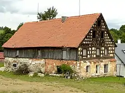 Half-timbered farmhouse | |
 Flag  Coat of arms | |
 Dolní Nivy Location in the Czech Republic | |
| Coordinates: 50°14′36″N 12°38′14″E / 50.24333°N 12.63722°E | |
| Country | |
| Region | Karlovy Vary |
| District | Sokolov |
| First mentioned | 1353 |
| Area | |
| • Total | 18.82 km2 (7.27 sq mi) |
| Elevation | 552 m (1,811 ft) |
| Population (2023-01-01)[1] | |
| • Total | 342 |
| • Density | 18/km2 (47/sq mi) |
| Time zone | UTC+1 (CET) |
| • Summer (DST) | UTC+2 (CEST) |
| Postal code | 356 01 |
| Website | www |
Dolní Nivy (German: Unter Neugrün) is a municipality and village in Sokolov District in the Karlovy Vary Region of the Czech Republic. It has about 300 inhabitants.
Administrative parts
Villages of Boučí, Horní Nivy and Horní Rozmyšl are administrative parts of Dolní Nivy.
References
Wikimedia Commons has media related to Dolní Nivy.
This article is issued from Wikipedia. The text is licensed under Creative Commons - Attribution - Sharealike. Additional terms may apply for the media files.