Dolenje Otave | |
|---|---|
 | |
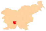
 Dolenje Otave Location in Slovenia | |
| Coordinates: 45°50′13.56″N 14°24′57.43″E / 45.8371000°N 14.4159528°E | |
| Country | |
| Traditional region | Inner Carniola |
| Statistical region | Littoral–Inner Carniola |
| Municipality | Cerknica |
| Area | |
| • Total | 2.04 km2 (0.79 sq mi) |
| Elevation | 793 m (2,602 ft) |
| Population (2020) | |
| • Total | 31 |
| • Density | 15/km2 (39/sq mi) |
| [1] | |
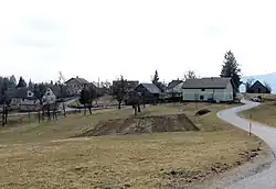
Dolenje Otave (pronounced [dɔˈleːnjɛ ɔˈtaːʋɛ]; German: Unterotawe[2]) is a small village in the hills northeast of Begunje in the Municipality of Cerknica in the Inner Carniola region of Slovenia.[3]
Name
The name Dolenje Otave literally means 'lower Otave', contrasting with the name of neighboring Gorenje Otave (literally, 'upper Otave'). The name is probably derived from the Slovene common noun otava 'second crop (of hay)', referring to a meadow or area where hay could be harvested twice during the summer.[4]
References
- ↑ Statistical Office of the Republic of Slovenia
- ↑ Leksikon občin kraljestev in dežel zastopanih v državnem zboru, vol. 6: Kranjsko. 1906. Vienna: C. Kr. Dvorna in Državna Tiskarna, p. 122.
- ↑ Cerknica municipal site
- ↑ Snoj, Marko (2009). Etimološki slovar slovenskih zemljepisnih imen. Ljubljana: Modrijan. p. 297.
External links
 Media related to Dolenje Otave at Wikimedia Commons
- Dolenje Otave on Geopedia
This article is issued from Wikipedia. The text is licensed under Creative Commons - Attribution - Sharealike. Additional terms may apply for the media files.
