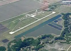
Dawson Creek Airport | |||||||||||
|---|---|---|---|---|---|---|---|---|---|---|---|
 Dawson Creek Airport, BC | |||||||||||
| Summary | |||||||||||
| Airport type | Public | ||||||||||
| Operator | City of Dawson Creek | ||||||||||
| Location | Dawson Creek, British Columbia | ||||||||||
| Time zone | MST (UTC−07:00) | ||||||||||
| Elevation AMSL | 2,147 ft / 654 m | ||||||||||
| Coordinates | 55°44′32″N 120°10′59″W / 55.74222°N 120.18306°W | ||||||||||
| Map | |||||||||||
 CYDQ Location in British Columbia | |||||||||||
| Runways | |||||||||||
| |||||||||||
| Statistics (2010) | |||||||||||
| |||||||||||
Dawson Creek Airport (IATA: YDQ, ICAO: CYDQ) is located 2 nautical miles (3.7 km; 2.3 mi) southeast of Dawson Creek, British Columbia, Canada.
See also
References
- ↑ Canada Flight Supplement. Effective 0901Z 16 July 2020 to 0901Z 10 September 2020.
- ↑ Synoptic/Metstat Station Information Archived December 1, 2011, at the Wayback Machine
- ↑ Total aircraft movements by class of operation
External links
Wikimedia Commons has media related to Dawson Creek Airport.
- Page about this airport on COPA's Places to Fly airport directory
- Past three hours METARs, SPECI and current TAFs for Dawson Creek Airport from Nav Canada as available.
This article is issued from Wikipedia. The text is licensed under Creative Commons - Attribution - Sharealike. Additional terms may apply for the media files.