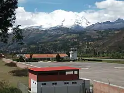
Comandante FAP Germán Arias Graziani Airport Anta-Huaraz/Huascaran Airport | |||||||||||
|---|---|---|---|---|---|---|---|---|---|---|---|
 German Arias Graziani Airport in Huaraz | |||||||||||
| Summary | |||||||||||
| Airport type | Public | ||||||||||
| Operator | ADP | ||||||||||
| Serves | Huaraz | ||||||||||
| Location | Anta, Peru | ||||||||||
| Elevation AMSL | 9,097 ft / 2,773 m | ||||||||||
| Coordinates | 9°20′50″S 77°35′55″W / 9.34722°S 77.59861°W | ||||||||||
| Map | |||||||||||
 ATA Location of the airport in Peru | |||||||||||
| Runways | |||||||||||
| |||||||||||
Comandante FAP Germán Arias Graziani Airport (IATA: ATA, ICAO: SPHZ) is a regional airport serving the city of Huaraz, Ancash Region, Peru. The airport is in the Santa River valley, 20 kilometres (12 mi) northwest of Huaraz, at the village of Anta. It is currently not served by any airline due to the bankruptcy of the scheduled airline, LC Perú. It receives many private and charter flights. It does not receive large aircraft due to high terrain in all quadrants.
The Anta-Huaraz non-directional beacon (Ident: ATA) is located on the field.[3][4]
See also
References
- ↑ Airport information for ATA at Great Circle Mapper.
- ↑ Google Maps - Anta
- ↑ OurAirports - ATA NDB
- ↑ SkyVector ATA
External links
- OurAirports - Anta
- SkyVector Aeronautical Charts
- OpenStreetMap - Anta
- Accident history for Anta at Aviation Safety Network
An earthquake devastated this area on May 31, 1970 and the USAF sent crews down to help with the recovery. Two USAF Combat Controllers were deployed to Anta, in the mountains, to convert an existing dirt roadway into a runway. During the week or so that they were constructing the runway, supplies were airdropped in for the people in the region. After about a week, aircraft were able to land with supplies and leave with injured.