Chotilsko | |
|---|---|
 Main road | |
 Flag  Coat of arms | |
 Chotilsko Location in the Czech Republic | |
| Coordinates: 49°46′14″N 14°21′9″E / 49.77056°N 14.35250°E | |
| Country | |
| Region | Central Bohemian |
| District | Příbram |
| First mentioned | 1359 |
| Area | |
| • Total | 27.23 km2 (10.51 sq mi) |
| Elevation | 340 m (1,120 ft) |
| Population (2023-01-01)[1] | |
| • Total | 602 |
| • Density | 22/km2 (57/sq mi) |
| Time zone | UTC+1 (CET) |
| • Summer (DST) | UTC+2 (CEST) |
| Postal code | 262 03 |
| Website | www |
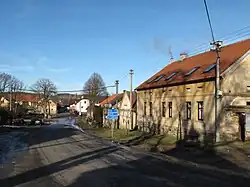
Chotilsko is a municipality and village in Příbram District in the Central Bohemian Region of the Czech Republic. It has about 600 inhabitants.
Administrative parts
Villages and hamlets of Cholín-Boubovny, Hněvšín, Knihy, Kobylníky, Křeničná, Lipí, Mokrsko, Prostřední Lhota, Sejcká Lhota, Smilovice, Záborná Lhota and Živohošť are administrative parts of Chotilsko.
References
Wikimedia Commons has media related to Chotilsko.
This article is issued from Wikipedia. The text is licensed under Creative Commons - Attribution - Sharealike. Additional terms may apply for the media files.