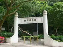
| Choi Sai Woo Park | |||||||||||
|---|---|---|---|---|---|---|---|---|---|---|---|
| Traditional Chinese | 賽西湖公園 | ||||||||||
| Simplified Chinese | 赛西湖公园 | ||||||||||
| |||||||||||


Choi Sai Woo Park (Chinese: 賽西湖公園) is an urban park located near the top of Braemar Hill at Braemar Hill Road, Hong Kong. The park serves as a social hub for the neighbourhood.
History
The park was named after the Choi Sai Woo Reservoir, which was formerly located in the park. According to the commemorative plaque in the park, the reservoir was built by Taikoo Sugar Company Limited in 1894; it was the largest and the last of the five private reservoirs built by the company. During the drought and bubonic plague outbreak that started in 1894, the reservoir once supplied water to Tai Ping Shan District. It was filled in by Li Ka-shing to create the current park site. In World War II it was the scene of bitter fighting as the Japanese advanced towards Wong Nai Chung Gap to split the defence of Hong Kong into two.
The park was built at a cost of $9.5 million and opened by the Urban Council in August 1986. It was designed to retain most of the existing mature trees and shrubs on site.[1] An opening ceremony, officiated by Urban Councillor Kim Cham and the Director of Urban Services, was held on 16 January 1987.[2]
Facilities

Choi Sai Woo Park is a landscaped garden with a total area of 2,400 m2 providing some country freshness among a number of housing estates and schools.[3] Located next to prestigious new housing developments and with several schools in the area, it serves the community as a place of rest. There are two small basketball courts in the Park. The garden area is located at the very bottom level of Choi Sai Woo Park abutting the car parking lot of TutorTime. It is mainly planted with bamboo. There is a children's playground located at the top of the park. A pagoda adjoins the playground. A number of amenities including restaurant or tea shop "cha chaan teng", Wan King, TutorTime and 7-Eleven outlets, are in the vicinity.
See also
- List of reservoirs of Hong Kong
- List of urban public parks and gardens in Hong Kong
- Braemar Hill Mansions, an adjacent housing estate
References
- ↑ "Monthly Report". Urban Council. Standing Committee of The Whole Council. 5 September 1986. p. 2.
- ↑ "Monthly Report". Urban Council. Standing Committee of The Whole Council. 6 February 1987. p. 1.
- ↑ Film Services Office: Choi Sai Woo Park