| Chiwaukum Mountains | |
|---|---|
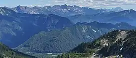
 The Chiwaukum Mountains (left and center skyline), looking south southeast, with Big Chiwaukum (8081 feet, 2463 m), the highest point | |
| Highest point | |
| Peak | Big Chiwaukum |
| Elevation | 2,463 m (8,081 ft) |
| Coordinates | 47°42′05″N 120°56′02″W / 47.70139°N 120.93389°W |
| Geography | |
| Country | United States |
| State | Washington |
| District | Wenatchee National Forest |
| Parent range | Wenatchee Mountains |
| Geology | |
| Age of rock | Cretaceous |
| Type of rock | schist |
The Chiwaukum Mountains are a north–south mountain range in central Washington, United States. They stretch from Snowgrass Mountain at 47°41′N 120°56′W / 47.683°N 120.933°W, to 47°45′N 120°54′W / 47.750°N 120.900°W.
The mountains are made of schist, part of the Nason terrane. The original rock in the Nason terrane was laid down 210 Myr ago. The terrane then smashed into the western coastline of the continent, and the Mount Stuart batholith intruded into it in the late Cretaceous. The intrusion of the granitic rock metamorphosed the rock into schist.[1]
In July 2014, the lightning-caused Chiwaukum Creek Fire burned the east flank of the Chiwaukum Mountains.
Partial list of peaks:
- Big Chiwaukum – 8,081' (2463m) – 47°42′09″N 120°56′05″W / 47.702385°N 120.934657°W[2]
- Snowgrass Mountain – 7,993' (2436m) – 47°41′01″N 120°56′09″W / 47.6837264°N 120.9359286°W[3]
- Big Lou – 7,780' (2370m) – 47°38′21″N 120°50′51″W / 47.639233°N 120.847482°W[4]
- Big Jim Mountain – 7,765' (2367m) – 47°39′43″N 120°49′49″W / 47.6620624°N 120.8303707°W[5]
- Ladies Peak – 7,708' (2349m) – 47°39′56″N 120°55′59″W / 47.665545°N 120.933131°W[6]
- Grindstone Mountain – 7,533' (2296m) – 47°38′12″N 120°54′48″W / 47.636646°N 120.913305°W[7]
- Cape Horn – 7,316' (2230m) – 47°39′26″N 120°55′04″W / 47.657206°N 120.917909°W[8]
- Bulls Tooth – 6,840' (2080m) – 47°40′57″N 121°00′14″W / 47.682633°N 121.003887°W[9]
Nearby peaks:
- Jim Hill Mountain – 6,765' (2062m) – 47°44′16″N 121°00′23″W / 47.7378906°N 121.0064869°W[10]
- Arrowhead Mountain – 6,020' (1835m) – 47°45′28″N 120°57′56″W / 47.7577524°N 120.9656397°W[11]
- Cowboy Mountain – 5,853' (1784m) – 47°43′56″N 121°05′55″W / 47.7323334°N 121.0987104°W[12]
See also
References
- ↑ "GEOLOGIC MAP OF THE CHELAN 30-MINUTE BY 60-MINUTE QUADRANGLE, WASHINGTON" (PDF). United States Geological Survey. Retrieved 2018-06-15.
- ↑ "Big Chiwaukum, Washington". PeakBagger.com. Retrieved 2018-06-15.
- ↑ "Snowgrass Mountain". Geographic Names Information System. United States Geological Survey, United States Department of the Interior. Retrieved 2018-06-14.
- ↑ "Big Lou, Washington". PeakBagger.com. Retrieved 2020-08-04.
- ↑ "Big Jim Mountain". Geographic Names Information System. United States Geological Survey, United States Department of the Interior. Retrieved 2018-06-14.
- ↑ "Ladies Peak, Washington". PeakBagger.com. Retrieved 2020-07-24.
- ↑ "Grindstone Mountain, Washington". PeakBagger.com. Retrieved 2020-06-26.
- ↑ "Cape Horn, Washington". PeakBagger.com. Retrieved 2020-07-24.
- ↑ "Bulls Tooth, Washington". PeakBagger.com. Retrieved 2020-06-24.
- ↑ "Jim Hill Mountain". Geographic Names Information System. United States Geological Survey, United States Department of the Interior. Retrieved 2018-06-14.
- ↑ "Arrowhead Mountain". Geographic Names Information System. United States Geological Survey, United States Department of the Interior. Retrieved 2020-07-11.
- ↑ "Cowboy Mountain". Geographic Names Information System. United States Geological Survey, United States Department of the Interior. Retrieved 2018-06-14.
This article is issued from Wikipedia. The text is licensed under Creative Commons - Attribution - Sharealike. Additional terms may apply for the media files.