Chilly | |
|---|---|
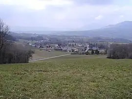 A general view of Chilly | |
Location of Chilly | |
 Chilly 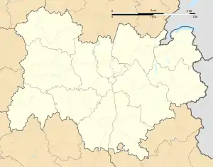 Chilly | |
| Coordinates: 45°59′33″N 5°57′13″E / 45.9925°N 5.9536°E | |
| Country | France |
| Region | Auvergne-Rhône-Alpes |
| Department | Haute-Savoie |
| Arrondissement | Saint-Julien-en-Genevois |
| Canton | Saint-Julien-en-Genevois |
| Intercommunality | CC Usses et Rhône |
| Government | |
| • Mayor (2020–2026) | Emmanuel Georges[1] |
| Area 1 | 18.58 km2 (7.17 sq mi) |
| Population | 1,577 |
| • Density | 85/km2 (220/sq mi) |
| Demonym | Chylliens |
| Time zone | UTC+01:00 (CET) |
| • Summer (DST) | UTC+02:00 (CEST) |
| INSEE/Postal code | 74075 /74270 |
| Elevation | 327–730 m (1,073–2,395 ft) |
| 1 French Land Register data, which excludes lakes, ponds, glaciers > 1 km2 (0.386 sq mi or 247 acres) and river estuaries. | |
Chilly (French pronunciation: [ʃiji]; Arpitan: Chelyi) is a commune in the Haute-Savoie department in the Auvergne-Rhône-Alpes region in south-eastern France.
The commune includes the hamlets of Botilly, Coucy, Curnillex, Darogne, Ferraz, Grange bouillet, Lacry, Les Vernays, Mannecy, Mougny, Novéry, planaise, Quincy et Vers grange.
See also
References
- ↑ "Répertoire national des élus: les maires" (in French). data.gouv.fr, Plateforme ouverte des données publiques françaises. 13 September 2022.
- ↑ "Populations légales 2021". The National Institute of Statistics and Economic Studies. 28 December 2023.
Wikimedia Commons has media related to Chilly (Haute-Savoie).
This article is issued from Wikipedia. The text is licensed under Creative Commons - Attribution - Sharealike. Additional terms may apply for the media files.