
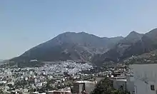
Chefchaouen is a province in the Moroccan economic region of Tanger-Tetouan-Al Hoceima.
Demographics
According to the 2014 national census in Morocco, the province has more than 457,432 inhabitants. The population is 87.45% rural.[1]
Geography
The province of Chefchaouen is bordered by five provinces – Tétouan Province to the northwest, Larache Province to the west, Al Hoceïma Province to the east, Taounate Province to the south, Ouezzane Province to the southwest – and the Mediterranean Sea to the northeast. The Province of Chefchaouen belongs to the Tanger-Tetouan-Al Hoceima Region and consists of one urban commune (the municipality of Chefchaouen) and 27 rural communes, giving the province a rural character.[2]
The city of Chefchaouen is the only official municipality in the province, created in 1975.[2] The other major towns are:[3]
Subdivisions
The province is divided administratively into the following:[4]
| Name | Geographic code | Type | Households | Population (2004) | Foreign population | Moroccan population | Notes |
|---|---|---|---|---|---|---|---|
| Chefchaouen | 151.01.01. | Municipality | 7739 | 35709 | 58 | 35651 | |
| Amtar | 151.03.01. | Rural commune | 1459 | 10038 | 0 | 10038 | |
| Bab Berred | 151.03.03. | Rural commune | 3879 | 23239 | 0 | 23239 | 5043 residents live in the center, called Bab Berred; 18196 residents live in rural areas. |
| Bni Ahmed Cherqia | 151.03.05. | Rural commune | 2021 | 10365 | 1 | 10364 | |
| Bni Ahmed Gharbia | 151.03.07. | Rural commune | 2286 | 12923 | 1 | 12922 | |
| Bni Rzine | 151.03.09. | Rural commune | 2630 | 19585 | 0 | 19585 | |
| Bni Smih | 151.03.11. | Rural commune | 2109 | 15577 | 0 | 15577 | |
| Iounane | 151.03.13. | Rural commune | 3085 | 23132 | 0 | 23132 | |
| Mansoura | 151.03.15. | Rural commune | 2664 | 16559 | 0 | 16559 | |
| M'Tioua | 151.03.17. | Rural commune | 1867 | 12076 | 0 | 12076 | 2984 residents live in the center, called Jebha; 9092 residents live in rural areas. |
| Ouaouzgane | 151.03.19. | Rural commune | 2279 | 16075 | 0 | 16075 | |
| Oued Malha | 151.03.21. | Rural commune | 1974 | 12088 | 0 | 12088 | |
| Tamorot | 151.03.23. | Rural commune | 3581 | 24541 | 0 | 24541 | |
| Bab Taza | 151.05.01. | Rural commune | 4544 | 28549 | 0 | 28549 | 4006 residents live in the center, called Bab Taza; 24543 residents live in rural areas. |
| Bni Darkoul | 151.05.03. | Rural commune | 1888 | 11706 | 0 | 11706 | |
| Bni Faghloum | 151.05.05. | Rural commune | 1603 | 9951 | 0 | 9951 | |
| Bni Salah | 151.05.07. | Rural commune | 1384 | 9662 | 0 | 9662 | |
| Derdara | 151.05.09. | Rural commune | 1644 | 10762 | 0 | 10762 | |
| Fifi | 151.05.11. | Rural commune | 1312 | 7720 | 0 | 7720 | |
| Laghdir | 151.05.13. | Rural commune | 1278 | 7077 | 0 | 7077 | |
| Tanaqoub | 151.05.15. | Rural commune | 1157 | 7219 | 0 | 7219 | |
| Bni Bouzra | 151.07.01. | Rural commune | 2245 | 15254 | 0 | 15254 | |
| Bni Mansour | 151.07.03. | Rural commune | 2468 | 18542 | 0 | 18542 | |
| Bni Selmane | 151.07.05. | Rural commune | 3090 | 23396 | 0 | 23396 | |
| Steha | 151.07.07. | Rural commune | 1695 | 10637 | 0 | 10637 | |
| Talambote | 151.07.09. | Rural commune | 1465 | 10659 | 0 | 10659 | |
| Tassift | 151.07.11. | Rural commune | 1193 | 8139 | 0 | 8139 | |
| Tizgane | 151.07.13. | Rural commune | 1883 | 11711 | 1 | 11710 | |
Environment
Mountains
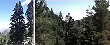
The Chefchaouen Mountains are composed of very rugged siliceous and limestone layers, with some peaks exceeding 2,000 m (6,600 ft) above sea level, such as Jbel Lakraa and Jbel Tissouka in the rural commune of Bab Taza, as well as Jbel Tizirane in the rural commune of Bab Berred.
Chefchaouen and its surroundings were historically and geographically known as the Jbala region or country (i.e. mountain inhabitants) where many Jbala tribes once lived. The Jbala region was officially described at the beginning of the 20th century as a geographical territory corresponding to the foothills of the southwestern Rif, between the massifs of the central Rif and the pre-Rif domain.[5][6]
Forests
Natural forests cover around 118,957 hectares (293,950 acres) and are dominated by broad-leaved trees. Forest formations are distributed according to local variations of climate and soil due to altitude, lithology, and human activity. There are sclerophyllous oaks such as cork oak (Quercus suber), holm oak (Quercus rotundifolia), and kermes oak (Quercus coccifera), deciduous oaks such as Tauzin oak (Quercus pyrenaica) and zeen oak (Quercus canariensis and Quercus faginea), and natural coniferous forests such as Maghreb maritime pine (Pinus pinaster var. maghrebiana), Moroccan fir (Abies maroccana) and Atlas cedar (Cedrus atlantica).[7]
The province of Chefchaouen is considered one of the richest regions in terms of biological diversity. It is designated as a Mediterranean biodiversity hotspot (i.e. a zone with an exceptional concentration of endemic and threatened species) and suffers from accelerated forest degradation due to anthropogenic pressures exacerbated by the impact of climate change. Two protected areas have been created in the province:[8][9]
- Talassemtane National Park, created in 2004, covers an area of about 60,000 ha (150,000 acres), 80% of which is in the province of Chefchaouen. The park extends over the eastern part of the limestone ridge of the central-western Rif, with cliffs and gorges making accessibility very limited. The park aims to protect the endemic Moroccan fir forest, and species such as Atlas cedar, black pine (Pinus nigra subsp. mauretanica), and Maghreb maritime pine. In terms of fauna, there are 37 mammal species including the threatened Barbary macaque (Macaca sylvanus), the otter (Lutra lutra), more than 117 birds including some rare or very rare raptors, and around thirty species of reptiles and amphibians.
- Bouhachem Regional Park, created in 2006 over an area of around 105,000 ha (260,000 acres), overlapping the provinces of Chefchaouen, Tetouan, and Larache. It was created to preserve natural forests and restore related natural resources and services.
In 2006, these two parks were included in the Mediterranean Intercontinental Biosphere Reserve of Spain and Morocco, established in the context of UNESCO's Man and the Biosphere (MAN) program. Reforestation programs have been carried out since 1966, and by 2016 had generated 16,119 ha (39,830 acres).[10]
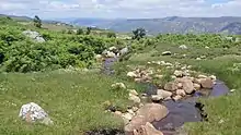
Water resources
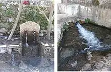
High rainfall at altitude provides a potential for hydrological development. Several seasonal rivers flow into the Mediterranean or feed the Loukos or Ouargha rivers.[11]
Economy
Agriculture and sea fishing
Despite the significant rainfall, agricultural activity is limited due to the rugged and steep topography, the scarcity of arable land, the low mechanization level, and the lack of irrigation infrastructure. These factors have contributed to the emergence of traditional agriculture largely dependent on climatic hazards. Forests have been harvested for wood and pulp products and to clear land for agriculture. Villagers from rural areas form an important workforce in the agricultural field.[12]
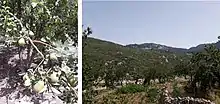
The province is dominated by cereal agriculture, goat herding in the mountains, and arboriculture of fig and almond trees.[12] The countryside has a reputation as a prolific source of kief. The Chefchaouen region is one of the main producers of cannabis in Morocco.
- Cereal cultivation: Occupying an area around 23,100 ha (57,000 acres), cereals are the most prevalent crops in the province;[12]
- Legumes: Legumes are cultivated over an area of around 3,220 ha (8,000 acres). Beans and broad beans are the most widely cultivated and occupy more than three-quarters of the area devoted to this type of crop;[12]
- Vegetable and forage crops: are cultivated over an area of about 180 ha (440 acres);[12]
- Fruit arboriculture: fruit tree plantations cover approximately 52,013 ha (128,530 acres), producing 654,930 quintals (65,493 tonnes) of fruit. The olive tree is the most widespread with 83% of the area, representing 66% of the total production.[12]
- Animal husbandry: Production of red meat is estimated at about 1,037.4 tons in 2016, of which 70% is beef, the rest mutton, and goat.[12][13]
- Maritime fishing: The province's 120 km (75 mi) of the Mediterranean coast recorded landings of 2,166 tons of fish in 2016, valued at 14.3 million Moroccan dirhams. 94.4% of landings were bluefish.[12]
This traditional agro-pastoral system – of olive and fig plantations, cereal fields, and limited grazing pastures – has been carried out for centuries. Local products are also diversified, such as fresh goat cheese and other animal products, medicinal and aromatic plants, and products based on wild olives, figs, wool, etc. These various agricultural models have contributed to a richness of food diversity and, in 2010, UNESCO recognized Chefchaouen for its Mediterranean diet.[14]
Industry and commerce
The industrial sector remains very weak despite the province's potential with its availability of human and natural resources. The commercial sector is one of the main economic supports of Chefchaouen, bolstered by tourism activity and remittances from workers abroad. It is mainly focused on urban centers and the main rural communes and is based on the sale of traditional food products, construction materials, clothing, and household items. Commercial transactions become dynamic during summer, with the influx of tourists and the return of foreign workers to the province.[12]
References
- ↑ "Recensement Général de la Population et de l'Habitat de 2014 : Population Légale du Maroc". Haut-Commissariat au Plan du Royaume du Maroc. Retrieved 2022-02-22.
- 1 2 Dipasquale, Letizia (2020). Understanding Chefchaouen: Traditional knowledge for a sustainable habitat. Firenze University Press. p. 69. ISBN 978-88-5518-177-8.
- ↑ "World Gazetteer".
- ↑ "Recensement général de la population et de l'habitat de 2004" (PDF). Haut-commissariat au Plan, Lavieeco.com. Archived from the original (PDF) on 24 July 2012. Retrieved 27 April 2012.
- ↑ Fay G., 1979. L’évolution d’une paysannerie montagnarde: les Jbalas Sud-Rifains (Evolution of a Mountain Landscape: The Jbalas of the Southern Rif). Méditerranée 1-2 : 81-91.
- ↑ Lazarev, G. Quelques hypothèses sur les dynamiques de peuplement du Rif occidental (Some Hypotheses on the Settlement Dynamics of the Eastern Rif). Critique économique, 30: 143-175. (2013)
- ↑ Taïqui, L. (2005). Evolution récente de la structure du paysage du Bassin de Chefchaouen (1958-1986). (Recent Evolution of the Landscape Structure of the Chefchaouen Basin (1958-1986)) In G.R.G.Rif Ed. Mutations des milieux ruraux dans les montagnes rifaines (Maroc), Série Etudes Spatiales (2), 1–19.
- ↑ Médail, F., & Quézel, P. (1997). Hot-Spots Analysis for Conservation of Plant Biodiversity in the Mediterranean Basin. Annals of the Missouri Botanical Garden, 84(1), 112–127.
- ↑ Royaume du Maroc 2005. Parc Naturel De Talassemtane. Evaluation de la Biodiversité et Suivi des habitats. Projet : Developpement Participatif Des Zones Forestieres Et Peri-Forestieres De La Province De Chefchaouen. MEDA/MAR/B7-4100/IB/98/0532. Assistance Technique.
- ↑ HCP (Haut-Commissariat au Plan), (2018). Monographie Rovinciale de Chefchaouen. Direction Régionale de Tanger-Tétouan- Al Hoceima, 105 p.
- ↑ بوشمال فاطمة، شفشاون حاضرة شريفة بملامح أندلوسية وقسمات جبلية، مجلة المناهل، العدد 98، ص 121-148، مطبعة دار المناهل، الرباط، 2020.
- 1 2 3 4 5 6 7 8 9 HCP (Haut-Commissariat au Plan), (2018). Monographie Rovinciale de Chefchaouen. Direction Régionale de Tanger-Tétouan- Al Hoceima, 105 p.
- ↑ Chebli, Y., Chentouf, M., Ozer, P., Hornick, J., & Cabaraux, J. (2018). Forest and silvopastoral cover changes and its drivers in northern Morocco. Applied Geography, 101, 23–35. https://doi.org/10.1016/j.apgeog.2018.10.006
- ↑ Chefchaouen inscrite au patrimoine de l’Unesco (Chefchaouen Registered in UNESCO Heritage). 20 November 2010. Bladi.net. Websil Sarl, Rabat. Accessed January 24, 2021)]
35°10′17″N 5°16′11″W / 35.17139°N 5.26972°W