| Canton Beach Central Coast, New South Wales | |||||||||||||||
|---|---|---|---|---|---|---|---|---|---|---|---|---|---|---|---|
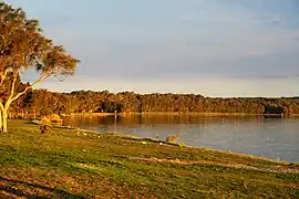
 Canton Beach in late afternoon sunlight | |||||||||||||||
 Canton Beach | |||||||||||||||
| Coordinates | 33°16.5′S 151°33′E / 33.2750°S 151.550°E | ||||||||||||||
| Population | 2,494 (2001 census)[1] | ||||||||||||||
| • Density | 2,270/km2 (5,870/sq mi) | ||||||||||||||
| Postcode(s) | 2263 | ||||||||||||||
| Elevation | 9 m (30 ft) | ||||||||||||||
| Area | 1.1 km2 (0.4 sq mi) | ||||||||||||||
| Location |
| ||||||||||||||
| LGA(s) | Central Coast Council | ||||||||||||||
| Parish | Wallarah | ||||||||||||||
| State electorate(s) | Wyong | ||||||||||||||
| Federal division(s) | Dobell | ||||||||||||||
| |||||||||||||||
Canton Beach is a suburb located on the Central Coast of New South Wales, Australia, as part of the Central Coast Council local government area.[2] It is next to Toukley which is a large residential and holiday town.
History
- Late 1850s – Chinese fishermen worked the Tuggerah Lakes area, in particular, what is now known as Canton Beach. While not confirmed, it is believed this is where the name is derived from. It was a base for catching and curing fish that were then shipped to Queensland, the goldfields and back to China.
- 1856 – Edward Hargraves purchased Robert Henderson's holdings and built "Norahville". Wollombi Aboriginal Tribe members are known to have worked on the property. Some sources state that Hargraves "befriended" tribe members. Cattle were grazed as far as Buff Point and Elizabeth Bay.
- 1903 – Lighthouse built at Norah Head after many vessels were wrecked in the area.
References
- ↑ Australian Bureau of Statistics (9 March 2006). "Noraville (State Suburb)". 2001 Census QuickStats. Retrieved 30 June 2007.
- ↑ "Canton Beach – Central Coast Australia". centralcoastaustralia.com.au. Retrieved 14 December 2021.
This article is issued from Wikipedia. The text is licensed under Creative Commons - Attribution - Sharealike. Additional terms may apply for the media files.