Cam Ranh
Thành phố Cam Ranh | |
|---|---|
| Cam Ranh City | |
.jpg.webp) A resort in Cam Ranh | |
|
Seal | |
 Cam Ranh Location of in Vietnam  Cam Ranh Cam Ranh (Southeast Asia)  Cam Ranh Cam Ranh (Asia) | |
| Coordinates: 11°54′49″N 109°8′13″E / 11.91361°N 109.13694°E | |
| Country | |
| Province | Khánh Hòa |
| Founded |
|
| Capital | Cam Ranh |
| Area | |
| • Total | 316 km2 (122 sq mi) |
| Population (2019) | |
| • Total | 138.510 |
| • Density | 438/km2 (1,130/sq mi) |
| Time zone | UTC+7 (Indochina Time) |
| Climate | Aw |
| Website | https://camranh.khanhhoa.gov.vn/english |
Cam Ranh (ⓘ) is a city in Southern Khánh Hòa Province, in the South Central Coast region of Vietnam.
Geography
It is the second-largest city in the province, after Nha Trang. It is located on Cam Ranh Bay. As of 2009 the city had a population of 121,050[1] and covered an area of 316 km².[2]
 Street in Cam Ranh
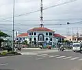 Post office
Infrastructure
- Cam Ranh International Airport
- Ba Ngòi Port
Climate
Cam Ranh has a tropical savanna climate (Köppen climate classification: As).[3][4]
| Climate data for Cam Ranh | |||||||||||||
|---|---|---|---|---|---|---|---|---|---|---|---|---|---|
| Month | Jan | Feb | Mar | Apr | May | Jun | Jul | Aug | Sep | Oct | Nov | Dec | Year |
| Record high °C (°F) | 33.3 (91.9) |
33.0 (91.4) |
34.5 (94.1) |
37.1 (98.8) |
39.0 (102.2) |
38.7 (101.7) |
39.0 (102.2) |
39.0 (102.2) |
37.5 (99.5) |
37.7 (99.9) |
33.5 (92.3) |
32.5 (90.5) |
39.0 (102.2) |
| Mean daily maximum °C (°F) | 28.3 (82.9) |
29.6 (85.3) |
31.0 (87.8) |
32.4 (90.3) |
33.4 (92.1) |
33.5 (92.3) |
33.4 (92.1) |
33.7 (92.7) |
32.4 (90.3) |
30.6 (87.1) |
29.2 (84.6) |
28.0 (82.4) |
31.3 (88.3) |
| Daily mean °C (°F) | 24.5 (76.1) |
25.1 (77.2) |
26.4 (79.5) |
28.1 (82.6) |
29.0 (84.2) |
29.1 (84.4) |
28.8 (83.8) |
28.9 (84.0) |
28.0 (82.4) |
26.8 (80.2) |
26.0 (78.8) |
24.9 (76.8) |
27.2 (81.0) |
| Mean daily minimum °C (°F) | 21.9 (71.4) |
22.1 (71.8) |
23.3 (73.9) |
24.8 (76.6) |
25.7 (78.3) |
25.8 (78.4) |
25.5 (77.9) |
25.6 (78.1) |
24.9 (76.8) |
24.2 (75.6) |
23.6 (74.5) |
22.7 (72.9) |
24.2 (75.6) |
| Record low °C (°F) | 14.4 (57.9) |
16.4 (61.5) |
17.1 (62.8) |
18.6 (65.5) |
21.5 (70.7) |
21.1 (70.0) |
21.3 (70.3) |
21.0 (69.8) |
21.6 (70.9) |
19.3 (66.7) |
18.7 (65.7) |
15.7 (60.3) |
14.4 (57.9) |
| Average precipitation mm (inches) | 24.4 (0.96) |
10.0 (0.39) |
38.0 (1.50) |
35.3 (1.39) |
89.4 (3.52) |
68.2 (2.69) |
53.9 (2.12) |
56.2 (2.21) |
167.1 (6.58) |
248.8 (9.80) |
319.6 (12.58) |
164.9 (6.49) |
1,324.5 (52.15) |
| Average rainy days | 5.6 | 2.6 | 3.1 | 4.0 | 8.9 | 8.5 | 8.6 | 9.1 | 13.5 | 15.8 | 14.8 | 11.6 | 105.9 |
| Average relative humidity (%) | 74.5 | 75.0 | 76.1 | 76.4 | 75.7 | 74.1 | 73.6 | 73.9 | 78.7 | 80.8 | 79.1 | 75.6 | 76.1 |
| Mean monthly sunshine hours | 214.7 | 237.0 | 272.0 | 266.4 | 255.5 | 224.0 | 234.6 | 230.9 | 199.0 | 182.5 | 169.5 | 164.7 | 2,640.9 |
| Source: Vietnam Institute for Building Science and Technology[5] | |||||||||||||
Gallery
 City Center for Political and Cultural Activities
 Headquarters of Cam Ranh City People's Committee
 Roundabout at the intersection of Hùng Vương Avenue and August 22 Street
References
- ↑ "Archived copy" (PDF). Archived from the original (PDF) on 2011-07-22. Retrieved 2011-05-21.
{{cite web}}: CS1 maint: archived copy as title (link) - ↑ "Districts of Vietnam". Statoids. Retrieved March 20, 2009.
- ↑ Kottek, Markus; Grieser, Jürgen; Beck, Christoph; Rudolf, Bruno; Rubel, Franz (2006). "World Map of the Köppen-Geiger climate classification updated" (PDF). Meteorologische Zeitschrift. 15 (3): 259–263. Bibcode:2006MetZe..15..259K. doi:10.1127/0941-2948/2006/0130.
- ↑ Peel, M. C.; Finlayson B. L. & McMahon, T. A. (2007). "Updated world map of the Köppen–Geiger climate classification" (PDF). Hydrol. Earth Syst. Sci. 11 (5): 1633–1644. Bibcode:2007HESS...11.1633P. doi:10.5194/hess-11-1633-2007. ISSN 1027-5606.
- ↑ "Vietnam Institute for Building Science and Technology" (PDF).
External links
Wikimedia Commons has media related to Cam Ranh.
Places adjacent to Cam Ranh | |
|---|---|
| Da Nang city |  | |
|---|---|---|
| Bình Định province | ||
| Bình Thuận province | ||
| Khánh Hòa province |
| |
| Ninh Thuận province | ||
| Phú Yên province | ||
| Quảng Nam province | ||
| Quảng Ngãi province | ||
※ denotes provincial seat. / § Sovereignty over the Hoàng Sa and Trường Sa archipelagoes is disputed as of 31 December 2023. | ||
This article is issued from Wikipedia. The text is licensed under Creative Commons - Attribution - Sharealike. Additional terms may apply for the media files.