Braňany | |
|---|---|
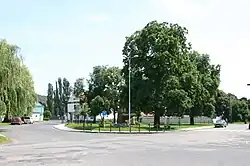 Common in Braňany | |
 Flag  Coat of arms | |
 Braňany Location in the Czech Republic | |
| Coordinates: 50°32′35″N 13°42′0″E / 50.54306°N 13.70000°E | |
| Country | |
| Region | Ústí nad Labem |
| District | Most |
| First mentioned | 1239 |
| Area | |
| • Total | 6.13 km2 (2.37 sq mi) |
| Elevation | 253 m (830 ft) |
| Population (2023-01-01)[1] | |
| • Total | 1,197 |
| • Density | 200/km2 (510/sq mi) |
| Time zone | UTC+1 (CET) |
| • Summer (DST) | UTC+2 (CEST) |
| Postal code | 435 22 |
| Website | www |
Braňany (German: Prohn) is a municipality and village in Most District at the Ústí nad Labem Region of the Czech Republic. It has about 1,200 inhabitants.
Braňany lies approximately 7 kilometres (4 mi) north-east of Most, 28 km (17 mi) south-west of Ústí nad Labem, and 72 km (45 mi) north-west of Prague.
Administrative parts
The hamlet of Kaňkov is an administrative part of Braňany.
References
Wikimedia Commons has media related to Braňany.
This article is issued from Wikipedia. The text is licensed under Creative Commons - Attribution - Sharealike. Additional terms may apply for the media files.