Bettendorf
Bettenduerf | |
|---|---|
 | |
 Coat of arms | |
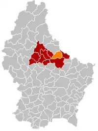 Map of Luxembourg with Bettendorf highlighted in orange, and the canton in dark red | |
| Coordinates: 49°53′00″N 6°13′00″E / 49.8833°N 6.2167°E | |
| Country | |
| Canton | Diekirch |
| Area | |
| • Total | 23.24 km2 (8.97 sq mi) |
| • Rank | 41st of 102 |
| Highest elevation | 422 m (1,385 ft) |
| • Rank | 34th of 102 |
| Lowest elevation | 180 m (590 ft) |
| • Rank | 16th of 102 |
| Population (2023) | |
| • Total | 3,052 |
| • Rank | 54th of 102 |
| • Density | 130/km2 (340/sq mi) |
| • Rank | 57th of 102 |
| Time zone | UTC+1 (CET) |
| • Summer (DST) | UTC+2 (CEST) |
| LAU 2 | LU0000601 |
| Website | bettendorf.lu |
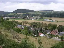
Bettendorf (Luxembourgish: Bettenduerf) is a commune and town in eastern Luxembourg. It lies along the river Sauer. It is part of the canton of Diekirch, which is part of the district of Diekirch.
As of 2001, the town of Bettendorf itself, which lies in the centre of the commune, has a population of 1,045. Other towns within the commune include Bleesbruck, Gilsdorf and Moestroff.
The privately owned Bettendorf Castle dates from 1728 and is built in the Baroque style.
Population
References
- ↑ "Population par canton et commune". statistiques.public.lu. Archived from the original on 2016-09-12. Retrieved 11 January 2022.
External links
 Media related to Bettendorf at Wikimedia Commons
Places adjacent to Bettendorf, Luxembourg | ||||||||||||||||
|---|---|---|---|---|---|---|---|---|---|---|---|---|---|---|---|---|
| ||||||||||||||||
 | ||
This article is issued from Wikipedia. The text is licensed under Creative Commons - Attribution - Sharealike. Additional terms may apply for the media files.