 | |
|---|---|
 | |
| Route information | |
| Major junctions | |
| South end | |
| North end |
|
| Location | |
| Country | Brazil |
| Highway system | |
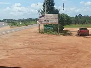
BR-156 is a federal highway of Brazil.[1][2]
The road consists of 552 km between Oiapoque and Macapá, and 271 km between Macapá and Laranjal do Jari (except via Santana city), totalling 823 km of road through forest and savannah.[1] Only the road between Macapá and Calçoene is paved with asphalt. The rest of the road has a dirt surface.[3]
Because of the road conditions, it takes around 10-12 hours to drive between Oiapoque and Macapá.[4]
With the Oyapock River Bridge (linking the cities of Oiapoque in Brazil and Saint-Georges-de-l'Oyapock in French Guiana) open to traffic starting from 20 March 2017, it is now possible to drive from Macapá to Cayenne, the capital city of French Guiana.[4]
References
- 1 2 "BR-156". Ministry of Transport. Archived from the original on 12 September 2012. Retrieved 7 June 2011.
- ↑ Rodovias Longitudinais
- ↑ "BR 156 map". Archived from the original on 2012-11-06. Retrieved 2013-04-09.
- 1 2 "Ponte entre Brasil e União Europeia é aberta no Amapá após 6 anos pronta". Amapá (in Brazilian Portuguese). 2017-03-18. Retrieved 2017-03-18.
Wikimedia Commons has media related to BR-156.
This article is issued from Wikipedia. The text is licensed under Creative Commons - Attribution - Sharealike. Additional terms may apply for the media files.