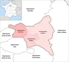
The 3 arrondissements of the Seine-Saint-Denis department are:[1]
- Arrondissement of Bobigny, (prefecture of the Seine-Saint-Denis département: Bobigny) with 9 communes. The population of the arrondissement was 415,958 in 2016.
- Arrondissement of Le Raincy, (subprefecture: Le Raincy) with 22 communes. The population of the arrondissement was 755,392 in 2016.
- Arrondissement of Saint-Denis, (subprefecture: Saint-Denis) with 9 communes. The population of the arrondissement was 435,310 in 2016.
History
In 1800 the arrondissement of Saint-Denis was established as part of the department Seine. In 1962 the arrondissement of Saint-Denis was disbanded,[2] and the arrondissement of Le Raincy was created as part of the department Seine-et-Oise.[3] The arrondissement of Bobigny was created in 1964 as part of the department Seine.[2] In 1968 the department Seine-Saint-Denis was created from parts of the former departments Seine and Seine-et-Oise, and the arrondissements of Bobigny and Le Raincy became part of it.[4] The arrondissement of Saint-Denis was recreated in February 1993 from part of the arrondissement of Bobigny.[5]
In January 2017 six communes passed from the arrondissement of Bobigny to the arrondissement of Le Raincy.[6]
References
- ↑ "Populations légales 2016" (PDF). INSEE. December 2018. Retrieved 2019-10-28.
- 1 2 Ancien département : la Seine
- ↑ Ancien département : la Seine-et-Oise
- ↑ Historique de la Seine-Saint-Denis
- ↑ Décret n° 93-259 du 26 février 1993 portant création de l'arrondissement de Saint-Denis (Seine-Saint-Denis)
- ↑ "Arrêté préfectoral, 30 December 2016" (PDF). pp. 25–27. Retrieved 2019-10-28.