Ards Lower
| |
|---|---|
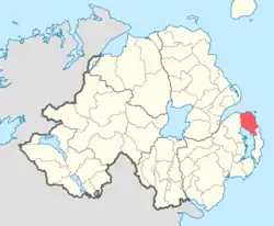 Location of Ards Lower, County Down, Northern Ireland. | |
| Coordinates: 54°35′54.89″N 5°36′17.10″W / 54.5985806°N 5.6047500°W | |
| Sovereign state | United Kingdom |
| Country | Northern Ireland |
| County | Down |
Ards Lower (named after the former barony of Ards), alternatively known as North Ards, is a barony in County Down, Northern Ireland.[2] It lies on the northern half of the Ards Peninsula in the north-east of the county, with the Irish Sea to its east and Strangford Lough to its south-west. It is bordered by two other baronies: Ards Upper to the south; and Castlereagh Lower to the west.[2]
The barony of Ards Lower was created in 1851 when the barony of Ards was split into two, the other part being Ards Upper.[3]
List of settlements
Below is a list of settlements in Ards Lower:[1][4]
Towns
- Bangor (also partly in barony of Castlereagh Lower)
- Donaghadee
- Newtownards (also partly in barony of Castlereagh Lower)
Villages
Population centres
- Clandeboye (split with the barony of Castlereagh Lower)
- Kilcooley
List of civil parishes
Below is a list of civil parishes in Ards Lower:[1][5][4]
- Bangor (also partly in barony of Castlereagh Lower)
- Donaghadee
- Greyabbey
- Newtownards (also partly in barony of Castlereagh Lower)
References
- 1 2 3 Logainm - Ards Lower
- 1 2 PRONI Baronies of Northern Ireland
- ↑ Database of Irish Historical Statistics - Literacy Notes
- 1 2 "Ards Lower". IreAtlas Townlands Database. Retrieved 15 May 2015.
- ↑ PRONI Civil Parishes of County Down

This article is issued from Wikipedia. The text is licensed under Creative Commons - Attribution - Sharealike. Additional terms may apply for the media files.