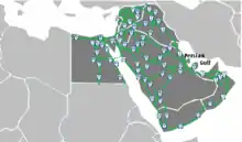
The map of the network
The Arab Mashreq international Road Network is an international road network between the primarily Arab countries of the Mashriq (Syria, Iraq, Jordan, Palestine, Lebanon, Kuwait, Egypt, Saudi Arabia, Bahrain, Qatar, UAE, Oman and Yemen). In addition, part of the network passes through Israel, which is not a party to the agreement that created it as well as non-Arab parts of the region. The network is a result of the 2001 Agreement on International Roads in the Arab Mashreq, a United Nations multilateral treaty that entered into force in 2003 and has been ratified by 13 of the 14 (all except Israel) countries that the network serves.[1][2]
Route List
| Number | Summary | Route | notes |
|---|---|---|---|
 | Iraq, East Arabian Peninsula | Zakho- Mosul – Baghdad – Samawa – Basrah – Safwan Abdally – Kuwait City – Nuwayseeb Khafji – Abu Hadriyah – Dammam – Hufuf – Salwa – Batha'a – Al-Ghuwaifat – Abu Dhabi – Dubai – Fujairah – Kalba Khatmat Malahaw – Sohar – Muscat – Nizwa – Thumrayt – Salalah | The section Dammam – Hufuf – Salwa will eventually be replaced by the coastal road (Dammam – Salwa) upon its completion. Connected to the European route E90 of the European International E-road network |
 | Abu Dhabi – Sohar | Abu Dhabi – Al-Ayn – Al-Buraimi – Sohar | |
 | Al-Ayn – Nizwa | Al-Ain – Mazyad – Hafit – Nizwa | |
 | Northern Iraq – East Mediterranean | Haj Omran – Erbil – Mosul – Rabieyyah Yaroubia – Qamishli – Aleppo – Lattakia | Connected to AH2 of the Asian Highway Network |
 | Aleppo – Ramadi | Aleppo – Deir Ez-Zor – Albu Kamal Al-Qa'em – Ramadi | |
 | Central Syria | Qamishli – Hasakah – Deir Ez-Zor – Homs – Tartus | |
 | Petroleum Pipeline | Hadithah – Ar'ar – Hafar El-Batin – Abu Hadriyah | |
 | Western Iraq – Eastern Mediterranean | Rutbah – Al-Walid Tanf – Damascus – Jedeidet Yabus Masna' – Beirut | |
 | Middle Arabian peninsula | Amman – Azraq – Omari Hadithah – Sakakah – Ha'il – Burayda – Riyadh – Al Kharj | |
 | Iraq, Jordan, Palestine, Western Israel, and the Mediterranean Southern Coast | Munthareya- Khanaqin – Baghdad – Ramadi – Rutbah – Tarabil Karamah – Al Azraq – Amman – King Hussein Bridge – Jerusalem – Ashdod – Gaza – Rafah – Arish – Kantara Bridge – Port Said – Alexandria – As Sallum | Connected to AH2 of the Asian Highway Network and Trans-African Highway Route 1 |
 | Syria – Jordan – Saudi Arabia – Yemen | Bab Al Hawa – Aleppo – Homs – Damascus – Nasib Jaber -Alsarhan – Amman – Qetraneh – Jorof – Ma'an – Al Mudawara Halat Ammar – Tabuk – Qaliba – Medina – Mecca – Abha – Elb Baqim – Sanaa – Ta'izz | |
 | Ma'an – Aqaba | Ma'an – Aqaba | |
 | Baghdad – Cairo | Baghdad – Karbala – Al Nukhaib – Jedeidat Ar'ar Jedeidat Ar'ar – Ar'ar – Sakakah – Qaliba – Tabuk – Ad-Durra – Aqaba – Eilat – Nuweiba – Nekhel – Shatt – Cairo | |
 | Eastern Mediterranean Coast | Kasab – Lattakia – Tartus – Dabboussieh Abboudieh – Tripoli – Beirut – Naqoura | |
 | Sinai – East Red Sea | Arish – Nakhel – Nuweiba Eilat Aqaba – Ad-Durra – Dhuba – Yanbu – Rabigh – Jeddah – Darb – At Tuwal Harad – Hodeidah – Al-Mukha | |
 | Western Saudi Arabia – Upper Egypt | Dhuba | |
 | Red Sea – West Coast | Ismailia – Suez – Safaga – Halayeb | |
 | Kuwait – Yanbu | Al-Kuwait – As-Salmi Ar-Ruqi – Hafar al-Batin – Al Artawiyah – Burayda – Medina – Yanbu | Eventually a section will be added upon being completed, branching off from this route at Artawiya and heading east to Jubail via Abu Hadriya |
 | Nile Valley | Alexandria – Cairo – Qena – Arqin | |
 | Manama – Jeddah | Manama -King Fahd Causeway- Dammam – Riyadh – Mecca – Jeddah | |
 | Doha – Ad-Darb | Doha – Abu Samra Salwah- Batha'a – Haradh – Al Kharj – Sulayyil – Abha – Ad-Darb | |
 | Southern Arabian Peninsula | Thumrayt – Mazyounah Shahan – Al Ghaydah – Al-Mukalla – Aden – Ta'izz – Al-Mukha | |
See also
Other intercontinental highway systems:
References
This article is issued from Wikipedia. The text is licensed under Creative Commons - Attribution - Sharealike. Additional terms may apply for the media files.