Anders Bure | |
|---|---|
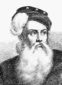 Later depiction of Anders Bure; no contemporary portraits exist of him.[1] | |
| Born | Andreas Bureus 14 August 1571 |
| Died | 4 February 1646 or 24 February 1646 (aged 74) |
| Spouse |
Kjerstin Krabbe (m. 1604) |
| Family | Bure kinship |
Anders Bure (before his ennoblement Andreas Bureus; 14 August 1571 – 4 or 24 February 1646[1]) was a Swedish cartographer, considered the "father of Swedish cartography". He worked in the royal chancellery and in 1603 was commissioned to produce a map of the Nordic countries by the future King Charles IX of Sweden. He produced a first map, covering the northern parts of Sweden, in 1611; it was considerably more accurate than earlier attempts at mapmaking and has been called the first real map of Sweden. It was followed by a more comprehensive map of Scandinavia in 1626, which would become a model for mapmakers for generations. In 1628, he became de facto the first head of Lantmäteriet, the Swedish Mapping, Cadastral, and Land Registration Authority. He was ennobled in 1624.
Biographical background and employment in the royal chancellery
Little is known about Bure's early life. He was born in Säbrå; his parents were Reverend Engelbertus Laurentii Bureus and his first wife Elisabet Andersdotter of the Bure kinship.[2] Two of his brothers also became prominent: Jonas Bure became head of the National Archives of Sweden, and his other brother Olof Bure became physician to King Gustavus Adolphus and also became mayor of Stockholm.[3][4] Anders Bure probably studied at Uppsala University or at a university abroad.[1][5][6] It is also possible that he received training from his cousin, the polymath Johannes Bureus, or perhaps from Johannes Rudbeckius.[5][6]
The first tangible information about the life of Bure dates from 1602, when he was assigned to bring order to a collection of documents for the royal chancellery, later filed in the national archive.[1] The job had earlier been offered to his cousin, who turned it down.[5] During this period, Bure acquired an astrolabe and, together with his cousin and a third person, produced a map of Stockholm.[1][5] Johannes Bureus further mentions in his diary that Anders Bure discussed the use of astronomic instruments with him, and that Bure on at least one occasion made stellar observations from Stockholm Palace.[7]
He would continue working within the royal chancellery (the precursor to the Government offices) with a variety of tasks, including diplomatic tasks concerning Russia.[1] In 1605 and again in 1634, he accompanied delegations to Russia, and he participated in a commission to regulate the border with Russia following the Treaty of Stolbovo.[1][8] He also participated in the negotiations leading to the Treaty of Knäred which ended the Kalmar War in 1613.[9]
He married Kjerstin Krabbe in 1604 and was ennobled in 1624, at the same time as his brother Jonas;[2] until his ennoblement, he used Bureus as his family name. He died in Stockholm.[1][10]
Cartography
Anders Bure has been called the "father of Swedish cartography".[1] In 1603, Bure received a commission from the future King Charles IX of Sweden (at the time Duke Charles) to make a map of the Nordic countries.[4] Charles had a personal interest in cartography, but the wider reasons were political, military and cameral; within a few generations the Swedish state would for these reasons finance and orchestrate the complete mapping of the country.[1][4]
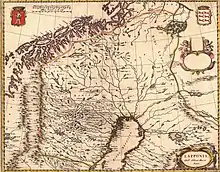
He produced a first map in 1611, covering the northern part of Sweden.[1] This limited range has been connected with the geopolitical ambitions of Charles IX, who entertained plans for a Swedish expedition towards the Arctic Ocean.[8] The map was based on substantial research, both archival research and, apparently, field studies, and was considerably more accurate than earlier depictions of the region.[1] For example, the river systems and lakes of northern Sweden are rendered in a basically correct way.[8] While nautical charts and relatively accurate maps existed for many areas around Sweden, no reliable map had hitherto been made of the country; the Carta marina made by Olaus Magnus in 1539 was geographically inaccurate (though ethnographically important).[3] Because of this, Bure's map — which had the Latin title Lapponise, Bothniae Cajaniseque regni Suecie provinciarum septentrionalium nova delineatio sculpta anno domini 1611 (often shortened to just Lapponia) — has been called the "first real map" of Sweden.[1][8][9] Historian Erik Vennberg notes in Svenskt biografiskt lexikon that "through its level of detail and correctness" the map constituted "extraordinary progress for its time, and was unprecedented in the Nordic countries".[1]

Bure worked for several years on the map he had originally been commissioned to make. Funding was supplied through royal patronage, including through a gift from King Gustavus Adolphus of more than 1,000 bibles, which Bure was to sell in order to get more money to the project.[1][11] In 1626 he could publish the map, covering most of Scandinavia, the present-day Baltic states and parts of Russia and northern Germany. Its Latin title is Orbis Arctoi, imprimisque amplissimi regni Sueciae tabula.[1] The map measures 113 by 117 centimetres (44 by 46 in), employs a simple conic projection, and a scale of 1:200,000. It was published in six sheets and accompanied by a commentary written by Bure.[12] This map was based on even more thorough research, and also data from contemporary Dutch maps. It was quickly copied by cartographers abroad and became widely distributed through atlases, and formed the basis for almost all maps of Sweden published outside the country until the end of the 18th century.[6][2] It has been called "the declaration of independence of Swedish cartography".[9]
Following these successes, Bure was given new tasks related to cartography in 1628. He was given the title generalmatematikus ("general mathematician"), a unique title in Swedish administration, only bestowed once through history.[13][14] His new job consisted in training new surveyors and producing maps of the provinces and cities of Sweden; in practice creating Lantmäteriet, the Swedish Mapping, Cadastral and Land Registration Authority, of which he became the first de facto head.[15][16] The instructions he wrote for the agency would be applied for the next 200 years.[14]
References
- 1 2 3 4 5 6 7 8 9 10 11 12 13 14 15 16 Vennberg 1926, p. 704.
- 1 2 3 Hofberg et al. 1906, p. 145.
- 1 2 Åberg 1968, p. 29.
- 1 2 3 Lindroth 1975, p. 481.
- 1 2 3 4 Åberg 1968, p. 30.
- 1 2 3 Lindroth 1975, p. 482.
- ↑ Åberg 1968, p. 31.
- 1 2 3 4 Åberg 1968, p. 32.
- 1 2 3 Dahl 1948, p. 503.
- ↑ Dahl 1948, pp. 503–504.
- ↑ Åberg 1968, p. 33.
- ↑ Lindroth 1975, pp. 482–483.
- ↑ "Generalmatematiker". Förvaltningshistorisk ordbok (in Swedish). Society of Swedish Literature in Finland. Retrieved November 2, 2023.
- 1 2 Dahl 1948, p. 504.
- ↑ Åberg 1968, p. 34.
- ↑ Lindroth 1975, pp. 483–484.
Sources cited
- Dahl, Torsten, ed. (1948). "Bure, Anders (Andreas)". Svenska män och kvinnor. Biografisk uppslagsbok [Swedish men and women. Biographical dictionary] (in Swedish). Vol. 1. Stockholm: Albert Bonnier. pp. 503–504. OCLC 4629338.
- Hofberg, Herman; Heurlin, Frithiof; Millqvist, Viktor; Rubenson, Olof, eds. (1906). "Bure, Anders". Svenskt biografiskt handlexikon [Swedish biographical handbook] (in Swedish). Vol. 1. Stockholm: Bonniers. p. 145. OCLC 474064019.
- Lindroth, Sten (1975). Svensk lärdomshistoria [Swedish history of learning] (in Swedish). Vol. 2: Stormaktstiden. Stockholm: PA Norstedt. ISBN 9789117540920.
- Vennberg, E. (1926). "Anders Bure". Svenskt biografiskt lexikon (in Swedish). Vol. 6. p. 704 – via Swedish National Archives.
- Åberg, Alf (1968). De fann Sverige åt oss [They discovered Sweden for us] (in Swedish). Stockholm: LT:s förlag. OCLC 14112563.
External links
 Media related to Anders Bure at Wikimedia Commons