Andahuaylas
Antawaylla | |
|---|---|
 Panorama | |
 Flag  Seal | |
 Andahuaylas Location in Peru | |
| Coordinates: 13°39′27″S 73°23′0″W / 13.65750°S 73.38333°W | |
| Country | |
| Region | Apurímac |
| Province | Andahuaylas |
| Government | |
| • Mayor | Abel Gutierrez Huezo |
| Area | |
| • Total | 370.03 km2 (142.87 sq mi) |
| Elevation | 2,926 m (9,600 ft) |
| Population (2017) | |
| • Total | 42,268 |
| • Estimate (2015)[1] | 63,654 |
| Time zone | UTC-5 (PET) |
| • Summer (DST) | UTC-5 (PET) |
| Area code | 83 |
| Website | www.andahuaylas.com |
Andahuaylas (Quechua Antawaylla, anta copper, waylla meadow, "copper meadow") is a Peruvian city. It is the capital of the Andahuaylas Province in the Apurímac Region. It is known as the pradera de los celajes (Spanish for "prairie of colored clouds"). Its approximate population of 42,268 inhabitants (2017 census) makes it the largest city in the region.
Geography
Andahuyalas is located in the western part of the Apurímac Region. The nearest city is Abancay.
Climate
| Climate data for Andahuaylas (elevation 2,981 m (9,780 ft), 1991–2020 normals) | |||||||||||||
|---|---|---|---|---|---|---|---|---|---|---|---|---|---|
| Month | Jan | Feb | Mar | Apr | May | Jun | Jul | Aug | Sep | Oct | Nov | Dec | Year |
| Mean daily maximum °C (°F) | 20.2 (68.4) |
19.8 (67.6) |
19.7 (67.5) |
20.1 (68.2) |
20.4 (68.7) |
19.8 (67.6) |
19.5 (67.1) |
20.0 (68.0) |
20.6 (69.1) |
21.4 (70.5) |
22.3 (72.1) |
21.2 (70.2) |
20.4 (68.8) |
| Mean daily minimum °C (°F) | 9.4 (48.9) |
9.6 (49.3) |
9.2 (48.6) |
7.7 (45.9) |
5.1 (41.2) |
4.2 (39.6) |
3.7 (38.7) |
5.0 (41.0) |
7.0 (44.6) |
8.0 (46.4) |
8.5 (47.3) |
9.3 (48.7) |
7.2 (45.0) |
| Average precipitation mm (inches) | 131.9 (5.19) |
128.5 (5.06) |
103.8 (4.09) |
38.4 (1.51) |
17.0 (0.67) |
77.2 (3.04) |
11.3 (0.44) |
17.9 (0.70) |
26.4 (1.04) |
48.0 (1.89) |
50.1 (1.97) |
92.8 (3.65) |
743.3 (29.25) |
| Source: National Meteorology and Hydrology Service of Peru[2] | |||||||||||||
Transportation
Andahuaylas is served by its own airport, the Andahuaylas Airport.
Gallery
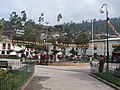 Central square of Andahuaylas
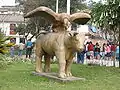 Statue on central square
 Mototaxis on the central square
See also
References
- ↑ Perú: Población estimada al 30 de junio y tasa de crecimiento de las ciudades capitales, por departamento, 2011 y 2015. Perú: Estimaciones y proyecciones de población total por sexo de las principales ciudades, 2012-2015 (Report). Instituto Nacional de Estadística e Informática. March 2012. Retrieved 2015-06-03.
- ↑ "Normales Climaticás Estándares y Medias 1991-2020". National Meteorology and Hydrology Service of Peru. Archived from the original on 21 August 2023. Retrieved 6 November 2023.
External links
Wikivoyage has a travel guide for Andahuaylas.
Pukllay, El verdadero carnaval originario de Perú. (www.pukllay.pe)
Journal of Andahuaylas
Diario Opinión
This article is issued from Wikipedia. The text is licensed under Creative Commons - Attribution - Sharealike. Additional terms may apply for the media files.