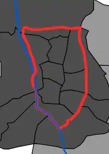
M-30 map
The Almendra Central (English: Central Almond) is a zone of Madrid comprising seven districts: Centro, Arganzuela, Retiro, Salamanca, Chamartín, Tetuán, and Chamberí,[1] (even though, sometimes, the City Council of Madrid includes part of an eighth, Moncloa-Aravaca,[2] specifically the Argüelles yard, all inside the M30 motorway.[3]
Population
In 1975 1,153,730 people lived there,[4] but since the 1990s, population has decreased steadily: in 2000 there were 915,318 inhabitants[4] and in 2011 847,686.
References
- ↑ "Observatorio Municipal de Vivienda: Boletín Trimestral" (PDF). madrid.es (in Spanish). Archived from the original (PDF) on 14 July 2014. Retrieved 29 September 2011.
- ↑ "Un plan estratégico para revitalizar los ocho distritos de la almendra central» Participación ciudadana". madrid.es (in Spanish). Retrieved 29 September 2011.
- ↑ "La almendra central de Madrid aglutina un bar o restaurante por cada 125 ciudadanos". La Vanguardia (in Spanish). Retrieved 29 September 2011.
- 1 2 Martínez Martín, Jesús A. «Madrid, de Villa a Metrópoli. Las transformaciones del siglo XX» Cuadernos de historia contemporánea Archived November 26, 2011, at the Wayback Machine 2000, número 22: 225-249 ISSN 0214-400X Consultado el 1 de octubre de 2011
Bibliography
- Roch Peña, Fernando (May 26, 2008). "La deriva patológica del espacio social en el modelo inmobiliario neoliberal madrileño". Diez años de cambios en el Mundo, en la Geografía y en las Ciencias Sociales, 1999-2008. Universidad de Barcelona.
{{cite book}}:|work=ignored (help) - Atlas de la Comunidad de Madrid en el umbral del siglo XXI: imagen socioeconómica de una región receptora de inmigrantes en Google Books
- Recuperar Madrid. Madrid: Ayuntamiento de Madrid, 1982. (Oficina Municipal del Plan).
This article is issued from Wikipedia. The text is licensed under Creative Commons - Attribution - Sharealike. Additional terms may apply for the media files.