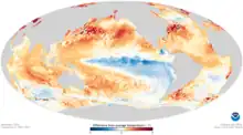
 Sea surface temperature anomalies across the world in November 2020 during the 2020–2023 La Niña event. | |
| Meteorological history | |
|---|---|
| Formed | July 2020 |
| Dissipated | March 2023 |
| Overall effects | |
| Damage | Significant |
| Areas affected | Pacific Ocean and surrounding areas |
The 2020–2023 La Niña event was a rare three-year, triple-dip La Niña.[1] The impact of the event led to numerous natural disasters that were either sparked or fueled by the La Niña. La Niña refers to the reduction in the temperature of the ocean surface across the central and eastern equatorial Pacific, accompanied by notable changes in the tropical atmospheric circulation. This includes alterations in wind patterns, pressure, and rainfall. The cold phase of the El Niño Southern Oscillation (ENSO), known as La Niña, typically produces contrasting effects on weather and climate compared to El Niño, which is the warm phase of the same phenomenon.[2]
Meteorological progression
Starting in 2020, the Pacific was in an ENSO-neutral condition that started in mid-2019, with no El Niño or La Niña occurring. In July 2020, various meteorological agencies declared La Niña conditions in the Pacific after observed cooling in the Niño 3.4 region. The first peak of the event occurred in late-2020, and the La Niña conditions soon decayed in March 2021, as ENSO-neutral was declared in the Pacific. The Niño 3.4 index hovered just below 0 °C (0 °F) for months, however it cooled down to −0.5 °C (−0.9 °F) in October 2021, for La Niña to be declared in the Pacific again. The La Niña then persisted until March 2023, when ENSO-neutral conditions were declared in the Pacific, with most agencies increasing the chance of El Niño occurring in the latter part of 2023.
Effects
There was record-setting tropical cyclone activity in the North Atlantic Ocean during the 2020 and 2021 hurricane seasons, with the 2020 season being the most active on record, and the 2021 season being the third-most active.[3][4] Numerous different catastrophic tropical cyclones, most notably hurricanes Laura, Eta, Iota, Ida, Fiona and Ian, made landfall during the event, leading to hundreds of billions of dollars in property damage to go alongside hundreds of deaths.
Australia and New Zealand
It led to Australia (especially New South Wales) experiencing one of its wettest Marchs on record following torrential rainfall in March 2021 during the 2021 eastern Australia floods, which resulted in over A$1 billion (about $670 million USD) in damage from destroyed homes and roads. In New Zealand, North Island experienced one of its wettest summers on record following the catastrophic events of the 2023 North Island floods, which resulted in roughly NZ$1.3 billion (about US$800 million) in damage. This came two years following the severe 2021 central New Zealand floods, which were also fueled by La Niña.
South America
In the Southern Cone of South America, heatwaves were registered during many consecutive summer seasons, causing fires and droughts in Argentina and in Chile. Additionally it led to the March 2022 Suriname floods, which occurred in eastern Suriname during March 2022.
References
- ↑ "La Niña is over. Here's what that means". www.cbsnews.com. 9 March 2023.
- ↑ "La Nina to persist till 2023. Know its influence on India's climate here". mint. 2022-06-10. Retrieved 2023-03-10.
- ↑ "El Niño/La Niña Southern Oscillation (ENSO)". public.wmo.int. 2018-04-04. Archived from the original on December 18, 2023. Retrieved 2023-03-10.
- ↑ "Triple-Dip La Niña persists, prolonging drought and flooding - World | ReliefWeb". reliefweb.int. 30 November 2022. Retrieved 2023-03-10.