111 Street | |||||||||||||||||||||||||||||||||||||||||||||||||||||||||||||||||||||||||||||||||||||||||||||||||||||||
|---|---|---|---|---|---|---|---|---|---|---|---|---|---|---|---|---|---|---|---|---|---|---|---|---|---|---|---|---|---|---|---|---|---|---|---|---|---|---|---|---|---|---|---|---|---|---|---|---|---|---|---|---|---|---|---|---|---|---|---|---|---|---|---|---|---|---|---|---|---|---|---|---|---|---|---|---|---|---|---|---|---|---|---|---|---|---|---|---|---|---|---|---|---|---|---|---|---|---|---|---|---|---|---|
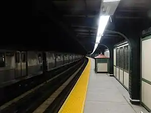
 Brooklyn bound platform | |||||||||||||||||||||||||||||||||||||||||||||||||||||||||||||||||||||||||||||||||||||||||||||||||||||||
| Station statistics | |||||||||||||||||||||||||||||||||||||||||||||||||||||||||||||||||||||||||||||||||||||||||||||||||||||||
| Address | 111th Street & Jamaica Avenue Queens, NY 11418 | ||||||||||||||||||||||||||||||||||||||||||||||||||||||||||||||||||||||||||||||||||||||||||||||||||||||
| Borough | Queens | ||||||||||||||||||||||||||||||||||||||||||||||||||||||||||||||||||||||||||||||||||||||||||||||||||||||
| Locale | Richmond Hill | ||||||||||||||||||||||||||||||||||||||||||||||||||||||||||||||||||||||||||||||||||||||||||||||||||||||
| Coordinates | 40°41′49″N 73°50′14″W / 40.696876°N 73.837223°W | ||||||||||||||||||||||||||||||||||||||||||||||||||||||||||||||||||||||||||||||||||||||||||||||||||||||
| Division | B (BMT)[1] | ||||||||||||||||||||||||||||||||||||||||||||||||||||||||||||||||||||||||||||||||||||||||||||||||||||||
| Line | BMT Jamaica Line | ||||||||||||||||||||||||||||||||||||||||||||||||||||||||||||||||||||||||||||||||||||||||||||||||||||||
| Services | J | ||||||||||||||||||||||||||||||||||||||||||||||||||||||||||||||||||||||||||||||||||||||||||||||||||||||
| Transit | |||||||||||||||||||||||||||||||||||||||||||||||||||||||||||||||||||||||||||||||||||||||||||||||||||||||
| Structure | Elevated | ||||||||||||||||||||||||||||||||||||||||||||||||||||||||||||||||||||||||||||||||||||||||||||||||||||||
| Platforms | 2 side platforms | ||||||||||||||||||||||||||||||||||||||||||||||||||||||||||||||||||||||||||||||||||||||||||||||||||||||
| Tracks | 3 (2 in passenger service) | ||||||||||||||||||||||||||||||||||||||||||||||||||||||||||||||||||||||||||||||||||||||||||||||||||||||
| Other information | |||||||||||||||||||||||||||||||||||||||||||||||||||||||||||||||||||||||||||||||||||||||||||||||||||||||
| Opened | May 28, 1917[2] | ||||||||||||||||||||||||||||||||||||||||||||||||||||||||||||||||||||||||||||||||||||||||||||||||||||||
| Closed | January 14, 2019 (reconstruction) | ||||||||||||||||||||||||||||||||||||||||||||||||||||||||||||||||||||||||||||||||||||||||||||||||||||||
| Rebuilt | June 11, 2019 | ||||||||||||||||||||||||||||||||||||||||||||||||||||||||||||||||||||||||||||||||||||||||||||||||||||||
| Opposite- direction transfer | Yes | ||||||||||||||||||||||||||||||||||||||||||||||||||||||||||||||||||||||||||||||||||||||||||||||||||||||
| Former/other names | Greenwood Avenue[2][3] 111th Street–Richmond Hill[2][3] | ||||||||||||||||||||||||||||||||||||||||||||||||||||||||||||||||||||||||||||||||||||||||||||||||||||||
| Traffic | |||||||||||||||||||||||||||||||||||||||||||||||||||||||||||||||||||||||||||||||||||||||||||||||||||||||
| 2022 | 414,879[4] | ||||||||||||||||||||||||||||||||||||||||||||||||||||||||||||||||||||||||||||||||||||||||||||||||||||||
| Rank | 397 out of 423[4] | ||||||||||||||||||||||||||||||||||||||||||||||||||||||||||||||||||||||||||||||||||||||||||||||||||||||
| |||||||||||||||||||||||||||||||||||||||||||||||||||||||||||||||||||||||||||||||||||||||||||||||||||||||
| |||||||||||||||||||||||||||||||||||||||||||||||||||||||||||||||||||||||||||||||||||||||||||||||||||||||
| |||||||||||||||||||||||||||||||||||||||||||||||||||||||||||||||||||||||||||||||||||||||||||||||||||||||
| |||||||||||||||||||||||||||||||||||||||||||||||||||||||||||||||||||||||||||||||||||||||||||||||||||||||
| |||||||||||||||||||||||||||||||||||||||||||||||||||||||||||||||||||||||||||||||||||||||||||||||||||||||
The 111th Street station is a skip-stop station on the BMT Jamaica Line of the New York City Subway. Located at the intersection of 111th Street and Jamaica Avenue in Richmond Hill, Queens, it is served at all times by the J train. The Z train skips this station when it operates.
History
This station was opened on May 28, 1917[2] by the Brooklyn Union Elevated Railroad, an affiliate of the Brooklyn Rapid Transit Company, replacing Cypress Hills as the line's terminus.[2]
The station was temporarily closed on January 14, 2019, for six months of structural repairs. As part of the work, the trackside girders and the platforms were replaced. Unlike the repairs done at 121st Street and 104th Street, which were done one platform at a time, both platforms were closed simultaneously to cut the work from 12 months to 6 months;[5] as a result, the station reopened on June 11, 2019.[6]
Station layout
| Platform level | Side platform | |
| Westbound local | ← ← | |
| Peak-direction express | No passenger service | |
| Eastbound local | | |
| Side platform | ||
| Mezzanine | Fare control, station agent, MetroCard machines | |
| Ground | Street level | Entrances/exits |
This elevated station has three tracks and two side platforms. The center track dead ends at bumper blocks on both sides of the station and has connections to both local tracks.[7] It is only used for train storage. It was formerly used to turn trains for the BMT Lexington Avenue Elevated trains from 1917 until 1950. The track was also used to store trains while the Jamaica Line was being torn down north of 121st Street and the Archer Avenue Line was being built.[8]
Both platforms have beige windscreens for their entire lengths and brown canopies with green frames and support columns except for a small section at the west (railroad south) end. Station signs are in the standard black with white lettering.[7]
The 1990 artwork here is called Five Points of Observation by Kathleen McCarthy. It resembles a human face when viewed from the street and is also featured on four other stations on the BMT Jamaica Line.[9]
Exits
The station's only entrance/exit is an elevated station house beneath the tracks. Inside fare control, there is a single staircase to each platform at their south ends and a waiting area that allows a free transfer between directions. Outside fare control, there is a turnstile bank, token booth, and two staircases going down to either eastern corners of Jamaica Avenue and 111th Street.[7][10]
This station formerly had another entrance/exit at the east (railroad north) end. The staircase to 113th Street was removed, but the elevated station house beneath the tracks and single staircase to each platform remain boarded up and intact. The station house is now used for storage and offices.[7][11]
References
- ↑ "Glossary". Second Avenue Subway Supplemental Draft Environmental Impact Statement (SDEIS) (PDF). Vol. 1. Metropolitan Transportation Authority. March 4, 2003. pp. 1–2. Archived from the original (PDF) on February 26, 2021. Retrieved January 1, 2021.
- 1 2 3 4 5
- "To Open Jamaica Av. Line.; Nearly Two and a Half Miles Ready for Operation Tonight". The New York Times. No. May 27, 1917. May 27, 1917. p. 24. Retrieved April 21, 2015.
- "Jamaica Avenue 'L' is an Old Story Already" (PDF). The Leader-Observer. No. May 31, 1917. May 31, 1917. p. 1. Archived (PDF) from the original on March 30, 2020. Retrieved April 19, 2016.
- Report of the Public Service Commission for the First District of the State of New York, Volume 1. New York State Public Service Commission. January 15, 1918. pp. 73, 81, 312–314. Retrieved April 20, 2015.
- 1 2 The New York Times, New Subway Line: Affords a Five-Cent Fare Between Manhattan and Jamaica, L.I., July 7, 1918, page 30
- 1 2 "Annual Subway Ridership (2017–2022)". Metropolitan Transportation Authority. 2022. Retrieved November 8, 2023.
- ↑ "Critical Structural Repairs Scheduled for 111 St Station on J Line". www.mta.info (Press release). Metropolitan Transportation Authority. December 21, 2018. Archived from the original on December 24, 2018. Retrieved December 23, 2018.
- ↑ "J Line - Weekday and Weekend Planned Service Change Update". mymtaalerts.com. June 11, 2019. Archived from the original on June 12, 2019. Retrieved June 12, 2019.
- 1 2 3 4 Cox, Jeremiah. "111 Street (J) - The SubwayNut". www.subwaynut.com. Archived from the original on March 3, 2016. Retrieved February 18, 2016.
- ↑ "J Train". Station Reporter. August 11, 2014. Archived from the original on September 27, 2011. Retrieved February 18, 2016.
- ↑ "111th Street-104th Street-Woodhaven Boulevard - 75th Street - Cypress Hills - Kathleen McCarthy - Five Points of Observation, 1990-93". web.mta.info. Metropolitan Transportation Authority. Archived from the original on August 26, 2019. Retrieved April 3, 2020.
- ↑ "MTA Neighborhood Maps: Kew Gardens" (PDF). Metropolitan Transportation Authority. 2018. Retrieved October 1, 2018.
- ↑ "www.nycsubway.org: BMT Nassau Street-Jamaica Line". www.nycsubway.org. Retrieved February 18, 2016.
External links
 Media related to 111th Street (BMT Jamaica Line) at Wikimedia Commons
- 111th Street entrance from Google Maps Street View
- Platforms from Google Maps Street View


