Černívsko | |
|---|---|
Village | |
.jpg.webp) Main road | |
 Černívsko Location in the Czech Republic | |
| Coordinates: 49°28′27″N 13°56′12″E / 49.47417°N 13.93667°E | |
| Country | |
| Region | South Bohemian |
| District | Strakonice |
| Municipality | Uzeničky |
| First mentioned | 1352 |
| Area | |
| • Total | 1.29 km2 (0.50 sq mi) |
| Elevation | 465 m (1,526 ft) |
| Population (2021)[1] | |
| • Total | 25 |
| • Density | 19/km2 (50/sq mi) |
| Time zone | UTC+1 (CET) |
| • Summer (DST) | UTC+2 (CEST) |
| Postal code | 387 44 |
Černívsko is a village and administrative part of Uzeničky in Strakonice District in the South Bohemian Region of the Czech Republic It has about 30 inhabitants.
History
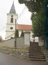
Church of the Holy Trinity
The first written mention of Černívsko is from 1352.[2]
Sights
The most important monument is the Church of the Holy Trinity in Černívsko. It was originally a Gothic building from the 14th century, which was rebuilt in the Baroque style in 1722.[3]
The Křikava Castle in dates from the 14th century and was first mentioned in 1357. It the 15th century, it was abandoned, probably as a result of the Hussite Wars. Today it is a ruin, with only a few fragments remaining.[4]
References
- ↑ "Výsledky sčítání 2021 – otevřená data" (in Czech). Czech Statistical Office. 2022-12-21.
- ↑ Historický lexikon obcí České republiky 1869–2005 (1. díl) (in Czech). Czech Statistical Office. p. 254. ISBN 80-250-1310-3.
- ↑ "Kostel Nejsvětější Trojice" (in Czech). National Heritage Institute. Retrieved 2023-04-12.
- ↑ "Hrad Křikava" (in Czech). National Heritage Institute. Retrieved 2023-04-12.
External links
 Media related to Černívsko at Wikimedia Commons
This article is issued from Wikipedia. The text is licensed under Creative Commons - Attribution - Sharealike. Additional terms may apply for the media files.