< Geographic Information System 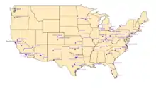
The buffer geoprocessing tool is used to create a polygon around the input feature. The size of the polygon depends on the distance specified when inputting the parameters. After the tool has run a new layer is created with the buffer polygons.
For example: This tool could be used by a delivery company to specify their delivery radius.
How to use:
The buffer tool is located under the Geoprocessing tab (See Figure 1).
Once you open the tool you must select an input feature, output feature, and the distance of your buffer (See Figure 2). There are additional options as well but are not necessary for a basic buffer.
After clicking OK, a new layer is created displaying the buffered areas (See Figures 3 and 4).
Figure 3
An example of a map before a buffer analysis.
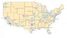
Figure 4
An example of a map after a buffer analysis
This article is issued from Wikiversity. The text is licensed under Creative Commons - Attribution - Sharealike. Additional terms may apply for the media files.