Page:The Ancient Geography of India.djvu/2
THE
ANCIENT GEOGRAPHY
OF
INDIA.
(Upload an image to replace this placeholder.)
TAYLOR AND CO., PRINTERS,
LITTLE QUEEN STREET, LINCOLN'S INN FIELDS.
CONTENTS.
Preface |
Page |
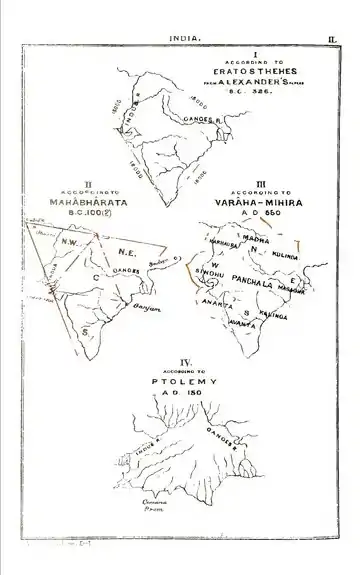
General Description |
1 |
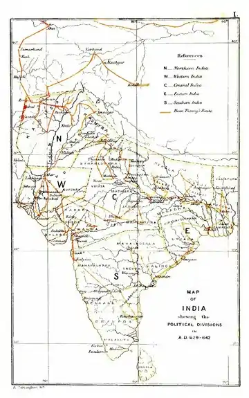
NORTHERN INDIA |
15 |
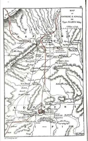
| I. | Kaufu, or Afghanistan |
17 |
| 1. | Kapisene, or Opiân |
18 |
Karsana, or Tetragonis, or Begram |
26 |
Other cities of Kapisene |
31 |
| 2. | Kophene, or Kabul |
32 |
| 3. | Arachosia, or Ghazni |
39 |
| 4. | Lamghân |
42 |
| 5. | Nagarahâra, or Jalalabad |
43 |
| 6. | Gândhâra, or Parashâwar |
47 |
Pushkalâvati, or Peukelaotis |
49 |
Varusha, or Paladheri |
49 |
Utakhanda, or Embolim (Ohind) |
52 |
Sålâtura, or Lahor. |
57 |
Aornos, or Rânigat |
58 |
Parashâwara, or Peshawar |
78 |
| 7. | Udyâna, or Swât |
81 |
| 8. | Bolor, or Balti |
83 |
| 9. | Falana, or Banu |
84 |
| 10. | Opokien, or Afghanistan (Loi, or Roh) |
87 |
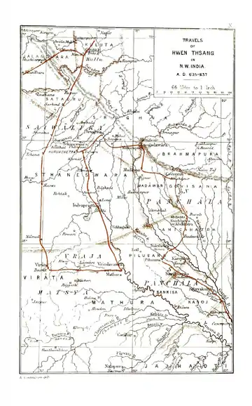
| II | KASHMIR |
89 |
| 1. | Kashmir (province) |
90 |
| 2. | Urasa |
103 |
| 3. | Taxila, or Takshasila |
104 |
Minikyâla |
78 |
| 4. | Singhapura, or Ketâs |
124 |
| 5. | Punacha, or Punach |
128 |
| 6. | Rajapuri, or Rajaori |
129 |
Hill-states of the Panjâb |
129 |
Jâlandhara |
130 |
Champa, or Chamba |
136 |
Kullu |
141 |
Mandi and Sukhet |
142 |
Nirpâr, or Pathâniya |
143 |
Satadru |
78 |
| VI | TAKI, OR PANJAB |
42 |
| 1. | Tâki, or Northern Panjâb |
47 |
Jobnâthnagar, or Bhira |
155 |
Bukephala, or Jalâlpur |
159 |
Nikaa, or Mong |
177 |
Gujarât |
179 |
Sakala, or Sangala |
179 |
(Upload an image to replace this placeholder.)
THE
ANCIENT GEOGRAPHY OF INDIA.
(Upload an image to replace this placeholder.)
| An image should appear at this position in the text. If you are able to provide it, see Wikisource:Image guidelines and Help:Adding images for guidance. |
| An image should appear at this position in the text. If you are able to provide it, see Wikisource:Image guidelines and Help:Adding images for guidance. |
(Improve this image)
| An image should appear at this position in the text. If you are able to provide it, see Wikisource:Image guidelines and Help:Adding images for guidance. |
| An image should appear at this position in the text. If you are able to provide it, see Wikisource:Image guidelines and Help:Adding images for guidance. |
- ↑ Geographia, ii. 1, 6.
- ↑ Strabo, x. 1, 11. The name of the author of the 'Stathmi' is preserved by Athenæus, i. 103. The original measurements were most probably made by Diognetus and Baiton, whose duty it was to ascertain the distances and lengths of Alexander's expeditions. See Plin. Hist. Nat., vi. 21.
This work was published before January 1, 1927, and is in the public domain worldwide because the author died at least 100 years ago.
This article is issued from Wikisource. The text is licensed under Creative Commons - Attribution - Sharealike. Additional terms may apply for the media files.