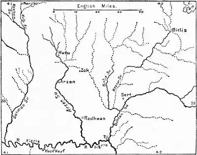
the highlands of Armenia and Kurdistan, and (when turned southward) running each its own independent course to the Persian Gulf. Like the Euphrates, the Tigris rises from two principal sources, of which the western and more distant—in 38° 10' N. lat. and about 39° 20' E. long—is a little south of Lake Giuljek, in a peninsula formed by the Euphrates, and some 2 or 3 miles only from the channel of that river. The names and sources of the different streams forming the Western Tigris—or that part of the upper river which runs, roughly speaking, from Diarbekr to the junction with the Eastern Tigris, about 50 miles north-north-west from Jezíra Ibn Omar—are given by Consul Taylor as the Arganeh M'adan and the Dibeneh Su, uniting at Ammaneh castle; the Ambar Su, rising at Heyni; the Batman Su, formed by the Kulp, the Kaushan, and the Sarum, rising north and north-west of Nerjiki; and the Khuzu or Huzu and the Arzen-Redhwan or Yezid Khaneh Su. Of the Eastern Tigris the chief tributaries are the Bohtan Su and its feeder the Bitlis (which receives the Keyzer or Shirwan), the Möx, the Shattak, the Chamkari, and the Sarhal Su. Of these the most northerly points may be found on the Kulp or Dibeneh Su about 38° 40' N. lat. and the most easterly on the Shattak in 42° 50' E. long.

Map showing the tributaries of the Tigris.
After the junction of the eastern and western branches (see the accompanying map) the river pursues a winding course, generally south-east, for about 800 miles, via Mosul and Baghdad, to the point of union with the Euphrates at Kurna, whence it becomes known as the Shattu 'l-Arab, and falls into the sea some 70 miles farther down. Between Mosul and Baghdad the Tigris receives from its left the Great and the Little Zab and other tributaries from the Kurdish Mountains. Below the confluence of the latter it is joined by the Diyála, also from the left, while on the right canals and watercourses connect it more or less directly with the Euphrates, which in the vicinity of Baghdad it approaches to within 30 or 35 miles. The Tigris is navigable for light freight-bearing steamers up to Baghdad, and for vessels of lighter draught to 20 miles below Mosul, but thence to Diarbekr only for rafts. "But owing to the rapidity of the current the traffic is all down stream, carried on mainly by a primitive style of craft, which is broken up at Baghdad and transported by camels back to Mosul. The journey between these points occupies three or four days during the floods and from twelve to fourteen at other times."
these names. The modern Arabic name is Dijla (Aramaic Deḳlath, Dīglā).