Weißeritzkreis
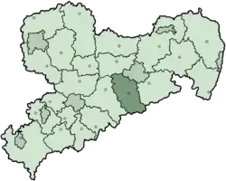
The Weißeritzkreis was a district (Kreis) in the south of the Free State of Saxony, Germany. It borders the Czech Republic. The district was created in 1994 when the two districts Dippoldiswalde and Freital were merged. It ended in 2008.
Weißeritzkreis | |
|---|---|
 Coat of arms | |
 | |
| Coordinates: 50.89°N 13.66°E | |
| Country | Germany |
| State | Saxony |
| Adm. region | Dresden |
| Disbanded | 2008 |
| Capital | Dippoldiswalde |
| Area | |
| • Total | 765 km2 (295 sq mi) |
| Population (2001) | |
| • Total | 124,091 |
| • Density | 160/km2 (420/sq mi) |
| Time zone | UTC+01:00 (CET) |
| • Summer (DST) | UTC+02:00 (CEST) |
| Vehicle registration | DW |
| Website | http://www.weisseritzkreis.com |
During the flooding in August 2002 the river Weißeritz had to drain many times the normal amount of water, and a lot of buildings in the river valley - houses, streets and bridges were destroyed
Partnerships
Coat of arms
|
The blue lines symbolise the two Weißeritz rivers, and their merging into a single river. The mining symbol in the bottom represents the old ore and coal mining tradition in the Ore Mountains. The tree stands for the rich forests in the district, and the lion to the right is the symbol of Meißen, as the area historically belonged to the margraviate of Meißen. |
Towns and municipalities
| Towns | Municipalities |
|---|---|
|
|
Other websites
- Official website Archived 2003-05-24 at the Wayback Machine (German)
- Website about the 2002 Flooding (German)
| Urban districts | |
|---|---|
| Rural districts | |
| Former urban districts | |
| Former rural districts | Annaberg · Aue-Schwarzenberg · Chemnitzer Land · Delitzsch · Döbeln · Freiberg · Kamenz · Leipziger Land · Löbau-Zittau · Mittlerer Erzgebirgskreis · Mittweida · Muldentalkreis · Niederschlesischer Oberlausitzkreis · Riesa-Großenhain · Sächsische Schweiz · Stollberg · Torgau-Oschatz · Weißeritzkreis · Zwickauer Land |
This article is issued from Wikipedia. The text is licensed under Creative Commons - Attribution - Sharealike. Additional terms may apply for the media files.