Vaigai River
The Vaigai River is a river that starts flowing from Varusanadu Hills, Periyar plateau of the Western Ghats range. This river flows east towards Tamil Nadu. The Vaigai river produces the Vattaparai Falls. The city of Madurai lies on the banks of this river. The river empties into the Palk strait in the Ramanathapuram district of Tamil Nadu.
| Vaigai River | |
|---|---|
 | |
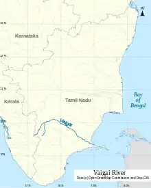 Map of Vaigai river | |
| Location | |
| Country | India |
| Physical characteristics | |
| Source | Varusanadu Hills |
| - location | Tamil Nadu, India |
| Mouth | |
| - location | Palk Bay, India |
| - elevation | 0 m (0 ft) |
| Length | 258 km (160 mi) |
| Discharge | |
| - average | 36 m3/s (1,300 cu ft/s) |
| Discharge | |
| - location | Peranai[1] |
| - average | 28.8 m3/s (1,020 cu ft/s) |

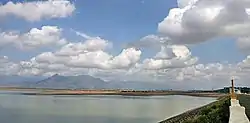
Vaigai River in Madurai, Tamil Nadu
Length
The Vaigai river flows for 256km (160mi). The area of the drainage basin of Vaigai is 7036 square kilometers.
Tributaries
The tributaries of Vaigai are Suruli River, Mullaiyaar River, Varaha River and Manjal River. The Kirudhumal River joins Vaigai river in Theni district. The water of Periyar river is diverted or turned to Vaigai.
Reference
- "Gauging Station – Data Summary". ORNL. Retrieved 1 October 2013.
This article is issued from Wikipedia. The text is licensed under Creative Commons - Attribution - Sharealike. Additional terms may apply for the media files.