Tuvan People's Republic
Tuvan People's Republic was a partially recognized state that existed from 1921 to 1944. After 1944 it became part of the Soviet Union. Until 1926, it was also known as People's Republic Tannu-Tuva. Only two states recognized the it: the Soviet Union and Mongolia. Even when it existed, it was seen as a puppet state of the Soviet Union. Its economy was largely based on nomads raising and selling cattle. The republic was between the Siberian part of Russia, and Mongolia. The capital was the city of Kyzyl. Since 1992, the territory is known as the Tuvan Republic. It is a self-governing part inside the Russian state.
Tuvan People's Republic Tьʙа Arat Respuʙlik | |||||||||||||
|---|---|---|---|---|---|---|---|---|---|---|---|---|---|
| 1921–1944 | |||||||||||||
.svg.png.webp) Flag
(1935–1939) .svg.png.webp) Emblem
(1935–1939) | |||||||||||||
| Anthem: Tooruktug Dolgay Tangdym[1] | |||||||||||||
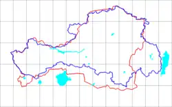 Blue line is the early border of the TPR. Red line is the Tuvan Autonomous Oblast border. | |||||||||||||
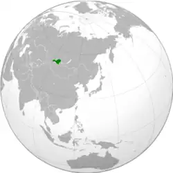 Location of the Tuvan People's Republic (modern-day boundaries). | |||||||||||||
| Status | Satellite state of the Soviet Union | ||||||||||||
| Capital | Kyzyl 51.698°N 94.390°E | ||||||||||||
| Common languages | |||||||||||||
| Religion | |||||||||||||
| Government | Unitary Marxist-Leninist single-party socialist republic | ||||||||||||
| First Secretary and Leader | |||||||||||||
• 1921–1922 (first) | Mongush Nimachap | ||||||||||||
• 1932–1944 (last) | Salchak Toka | ||||||||||||
| Head of state | |||||||||||||
• 1921 (first) | Mongush Buyan-Badyrgy | ||||||||||||
• 1940–1944 (last) | Khertek Anchimaa-Toka | ||||||||||||
| Head of government | |||||||||||||
• 1921–1922 (first) | Sodnam Balkhyr | ||||||||||||
• 1941–1944 (last) | Saryg-Donggak Chymba | ||||||||||||
| Legislature | People's Khural[2][3] | ||||||||||||
| Historical era | Interwar period, World War II | ||||||||||||
• Independence | 14 August 1921 | ||||||||||||
• Annexed by the USSR | 11 October 1944 | ||||||||||||
| Population | |||||||||||||
• 1931 | 82,200 | ||||||||||||
• 1944[4] | 95,400 | ||||||||||||
| Currency | Tuvan akşa | ||||||||||||
| |||||||||||||
| Today part of | Russia | ||||||||||||
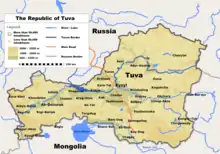
Map of the modern Republic of Tuva. The People's replubvlic had mostly the same borders.

Landscape
References
- Minahan, James (2009). The Complete Guide to National Symbols and Emblems. ABC-CLIO. p. 193. ISBN 978-0313344978.
- "О министерстве" (in Russian). Archived from the original on 2023-07-14. Retrieved 2021-11-08.
- "стория парламентаризма в Республике Тыва" (in Russian).
- Новые исследования Тувы. Электронный журнал «Новые исследования Тувы» (in Russian). Retrieved 2018-08-18.
This article is issued from Wikipedia. The text is licensed under Creative Commons - Attribution - Sharealike. Additional terms may apply for the media files.