Federally Administered Tribal Areas
The Federally Administered Tribal Areas (FATA) (Urdu: قبائلی علاقہ جات) in Pakistan were areas of Pakistan outside the four provinces, comprising a region of some 27,220 km² (10,507 mi²). The FATA were merged with the province of Khyber-Pakhtunkhwa in 2017. Miran Shah was the tribal capital. There are seven areas known as Agencies and six areas known as Frontier Regions.
- Bajaur Agency
- Khyber Agency
- Kurram Agency
- Mohmand Agency
- Orakzai Agency
- North Waziristan Agency
- South Waziristan Agency
Federally Administered Tribal Areas
(Pashto: منځنۍ پښتونخوا) | |
|---|---|
 Bab-e-Khyber | |
 Seal | |
.svg.png.webp) Location of the Federally Administered Tribal Areas | |
| Coordinates: 33°0′N 70°10′E | |
| Country | |
| Administrative unit | Federal territory |
| Components | 7 Agencies 6 Frontier Regions |
| Administrative centre | Peshawar |
| Government | |
| • Governor of Khyber-Pakhtunkhwa | Syed Masood Kausar |
| Area | |
| • Total | 27,220 km2 (10,510 sq mi) |
| Population | |
| • Total | 3,176,331 |
| • Density | 120/km2 (300/sq mi) |
| Time zone | UTC+5 |
| Website | http://www.fata.gov.pk/ |

Frontier Regions
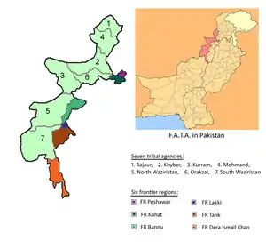
The Frontier Regions are named after their adjacent settled districts. The administration of the FR is carried out by the DCO / DC of the neighbouring named district. The overall administration of the frontier regions is carried out by the FATA Secretariat, based in Peshawar and reporting to the Governor of Khyber-Pakhtunkhwa. The six regions are:
- Frontier Region Bannu
- Frontier Region Dera Ismail Khan
- Frontier Region Kohat
- Frontier Region Lakki Marwat
- Frontier Region Peshawar
- Frontier Region Tank (Jandola)
Geography
The FATA are bordered by: Afghanistan to the west with the border marked by the Durand Line, Khyber-Pakhtunkhwa to the north and east, and Balochistan to the south.
The seven Tribal Areas lie in a north-to-south strip that is adjacent to the west side of the six Frontier Regions, which also lie in a north-to-south strip. The areas within each of those two regions are geographically arranged in a sequence from north to south.
The geographical arrangement of the seven Tribal Areas in order from north to south is: Bajaur Agency, Mohmand Agency, Khyber, Orakzai Agency, Kurram, North Waziristan, South Waziristan. The geographical arrangement of the six Frontier Regions in order from north to south is: Peshawar, Kohat, Bannu, Lakki Marwat, Tank, Dera Ismail Khan.
References
- "Area, Population, Density and Urban/Rural Proportion by Administrative Units". Population Census Organization, Government of Pakistan. Archived from the original on 2010-12-22. Retrieved 2010-04-11.
- "Population". FATA Secretariat. Archived from the original on 2009-03-03. Retrieved 2010-04-11.
| Provinces | ||
|---|---|---|
| Territories | ||
| Autonomous regions | ||
See also: Subdivisions of Pakistan | ||