Sulu
Sulu ([sʊˈlu]; Tausūg: Wilāya sin Lupa' Sūg; Tagalog: Lalawigan ng Sulu) is a province of the Philippines in the Sulu Archipelago and part of the Bangsamoro Autonomous Region in Muslim Mindanao (BARMM).
Sulu
| |
|---|---|
| Province of Sulu | |
 Sulu Provincial Capitol Building in Jolo | |
 Flag  Seal | |
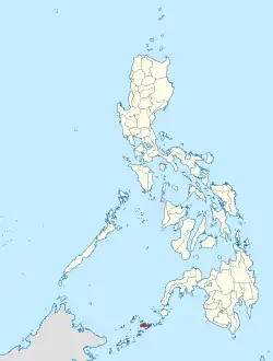
 Location in the Philippines | |
OpenStreetMap | |
| Coordinates: 6°N 121°E | |
| Country | Philippines |
| Region | Bangsamoro |
| Founded | March 10, 1917 |
| Capital |
|
| Government | |
| • Type | Sangguniang Panlalawigan |
| • Sultan | Muedzul Lail Tan Kiram |
| • Governor | Abdusakur M. Tan |
| • Vice Governor | Abdusakur A. Tan II |
| Area | |
| • Total | 1,600.40 km2 (617.92 sq mi) |
| • Rank | 66th out of 81 |
| Highest elevation (Bud Dajo) | 620 m (2,030 ft) |
| Population (2020 census) | |
| • Total | 1,000,108 |
| • Rank | 33rd out of 81 |
| • Density | 620/km2 (1,600/sq mi) |
| • Rank | 10th out of 81 |
| Divisions | |
| • Independent cities | 0 |
| • Component cities | 0 |
| • Municipalities | 19
|
| • Barangays | 410 |
| • Districts | 1st and 2nd districts of Sulu |
| Time zone | UTC+8 (PHT) |
| ZIP code | 7400–7416 |
| IDD : area code | +63 (0)68 |
| ISO 3166 code | PH-SLU |
| Spoken languages | |
| Income classification | 2nd class |
References
- "Brief Profile". Province of Sulu, Philippines. Archived from the original on 26 February 2011. Retrieved 18 April 2016.
Various government agencies report varying land areas for Sulu. According to the National Mapping and Resources Information Authority, Sulu has a total land area of 160,040 hectares. On the other hand, based on the Philippine Statistics Authority (NSO) 2000 Demographic and Socio-Economic profile, the province has a land area of 1,754.6.
- Province of Sulu: Brief Profile Archived 2011-02-26 at the Wayback Machine (There seems to be major discrepancies among authoritative sources: 343,699 ha (NSCB 2007), 175,460 ha (NSCB 2000), 167,377 ha (NAMRIA))
- "Jolo Branch Museum". National Museum. Archived from the original on August 2, 2019. Retrieved February 22, 2020.
This article is issued from Wikipedia. The text is licensed under Creative Commons - Attribution - Sharealike. Additional terms may apply for the media files.