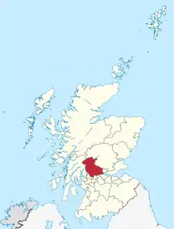
Stirling (council area)
Stirling (Sruighlea in Gaelic) is one of the 32 unitary local government council areas of Scotland, and has a population of about 85,000.
Stirling
Sruighlea Stirlin | |
|---|---|
 | |
| Admin HQ | Stirling |
| Government | |
| • Body | Stirling Council |
| • Control | SNP + Lab (council NOC) |
| • MPs |
|
| • MSPs |
|
| Area | |
| • Total | 844 sq mi (2,186 km2) |
| • Rank | Ranked 9th |
| Population (mid-2016 est.) | |
| • Total | 93,800 |
| • Rank | Ranked 24th |
| • Density | 110/sq mi (42/km2) |
| ONS code | S12000030 |
| ISO 3166 code | GB-STG |
| Website | www |
Towns and villages
- Aberfoyle
- Ardchyle
- Ardeonaig
- Arnprior
- Balmaha
- Bannockburn
- Blair Drummond
- Boreland
- Bridge of Allan
- Brig o' Turk
- Buchlyvie
- Callander
- Cambuskenneth
- Campsie
- Cowie
- Craigdownings
- Craigruie
- Crianlarich
- Croftamie
- Dalmary
- Doune
- Drymen
- Dunblane
- Fallin
- Fintry
- Gargunnock
- Gartmore
- Gartness
- Inversnaid
- Killearn
- Killin
- Kinbuck
- Kinlochard
- Kippen
- Lecropt
- Lochearnhead
- Mid Lecropt
- Milton
- Mugdock
- Port of Menteith
- Plean
- Raploch
- Rowardennan
- Strathyre
- Stronachlachar
- Thornhill
- Throsk
- Torbrex
- Tyndrum
- St Ninians
- Stirling
- Strathblane
This article is issued from Wikipedia. The text is licensed under Creative Commons - Attribution - Sharealike. Additional terms may apply for the media files.