Spiekeroog
Spiekeroog is one of the East Frisian Islands, off the North Sea coast of Germany. It is between Langeoog to its west and Wangerooge to its east. The island belongs to the municipality of the district of Wittmund, in Lower Saxony, Germany. The only village on the island is also called Spiekeroog.
Spiekeroog | |
|---|---|
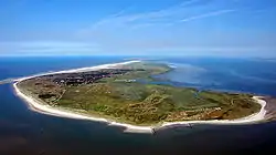 Aerial view of Spiekeroog from the west | |
 Coat of arms | |
Location of Spiekeroog within Wittmund district 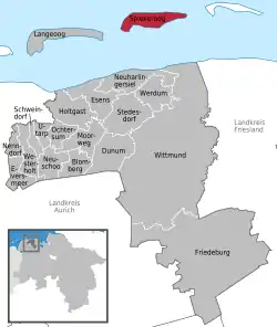 | |
 Spiekeroog 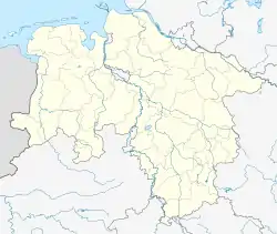 Spiekeroog | |
| Coordinates: 53°46′19″N 7°41′49″E | |
| Country | Germany |
| State | Lower Saxony |
| District | Wittmund |
| Government | |
| • Mayor | Bernd Fiegenheim |
| Area | |
| • Total | 18.25 km2 (7.05 sq mi) |
| Elevation | 3 m (10 ft) |
| Population (2022-12-31)[1] | |
| • Total | 841 |
| • Density | 46/km2 (120/sq mi) |
| Time zone | UTC+01:00 (CET) |
| • Summer (DST) | UTC+02:00 (CEST) |
| Postal codes | 26474 |
| Dialling codes | 0 49 76 |
| Vehicle registration | WTM |
| Website | www |
Spiekeroog covers an area of 18.25 square kilometres (7.05 square miles), the shortest distance to the land is 5.7 kilometres (3.5 miles). The island is - with the exception of fire and rescue vehicles - free of cars. A daily ferry service with the harbour of Neuharlingersiel connects the island with the German mainland.
References
This article is issued from Wikipedia. The text is licensed under Creative Commons - Attribution - Sharealike. Additional terms may apply for the media files.