Shenandoah River
The Shenandoah River /ˌʃɛnənˈdoʊə/ is a tributary of the Potomac River, 55.6 miles (89.5 km) long with two forks approximately 100 miles (160 km) long each.[3] One is in the U.S. states of Virginia while the other in West Virginia.
| Shenandoah River | |
|---|---|
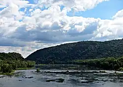 Crossing the Shenandoah River in Harpers Ferry, West Virginia | |
 Shenandoah River drainage basin | |
| Location | |
| Country | United States |
| State | Virginia, West Virginia |
| Towns | Harper's Ferry, WV, Front Royal, VA, Luray, VA |
| Physical characteristics | |
| Source | North Fork |
| - location | Shenandoah Mountain |
| 2nd source | South Fork |
| - location | Port Republic |
| Source confluence | |
| - location | Front Royal, VA |
| Mouth | Potomac River |
| - location | Harpers Ferry |
| - coordinates | 39.3226009°N 77.7277704°W[1] |
| - elevation | 246 ft (75 m)[1] |
| Length | 56 mi (90 km) |
| Basin size | 2,937 sq mi (7,610 km2) |
| Discharge | |
| - location | Millville, WV[2] |
| - average | 2,755 cu ft/s (78.0 m3/s) |
| Basin features | |
| Tributaries | |
| - left | North Fork (Shenandoah River) |
| - right | South Fork (Shenandoah River) |
The river and its tributaries drain the central and lower Shenandoah River valley. They also drain the Page Valley in the Appalachians on the west side of the Blue Ridge Mountains, in northwestern Virginia and the Eastern Panhandle of West Virginia.[4]
Geology
The Shenandoah Valley sits on limestone. The fertile soil made it an attractive place for early settlement. It continues to be a major agricultural area of Virginia and West Virginia.
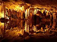
Some karst topography is evident, and the limestone has a great number of caves. Several have been developed as commercial tourist attractions. These include Luray Caverns, Shenandoah Caverns, and the Skyline Caverns.
On the riverbank a few miles above Harpers Ferry, West Virginia is said to be a cave with an opening just large enough for a rider on horseback to squeeze through. It widened in the interior to a spacious room where hundreds of Col. John Mosby's raiding troops are said to have hidden from pursuing Union cavalry.[5]
References
- "Shenandoah River". Geographic Names Information System. United States Geological Survey.
- "USGS 01636500 Shenandoah at Millville, WV" (PDF). National Water Information System. U.S. Geological Survey. 1895–2013. Retrieved 24 May 2014.
- U.S. Geological Survey. National Hydrography Dataset high-resolution flowline data. The National Map Archived 2017-08-23 at the Wayback Machine, accessed August 15, 2011
- U.S. Geological Survey Geographic Names Information System: Shenandoah River
- Virgil Carrington Jones, Mosby's Rangers (Chapel Hill & University of North Carolina Press, 1944), p. 240 (The Union discovered Mosby's cave only by accident late in the war when a wandering horse fell through a trap door hidden in a burnt-out house on the bluff above the river. A curious Union soldier noticed stairs leading downward, which proved to be the second entrance to the cave. There were stalls, hay, and room enough for 200 to 300 horses).
Other websites
![]() Media related to Shenandoah River at Wikimedia Commons
Media related to Shenandoah River at Wikimedia Commons