Santander Department
Santander is a department of Colombia. Its capital is the city of Bucaramanga.
Department of Santander
Departamento de Santander | |
|---|---|
.svg.png.webp) Flag  Coat of arms | |
| Motto(s): Santandereanos siempre adelante (Spanish: People of Santander always ahead) | |
| Anthem: Himno de Santander | |
.svg.png.webp) Santander shown in red | |
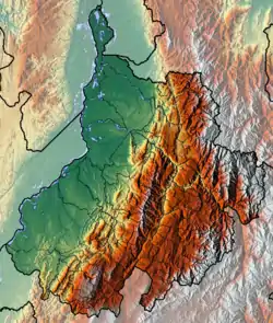 Topography of the department | |
| Coordinates: 7°8′N 73°0′W | |
| Country | |
| Region | Andean Region |
| Established | May 13, 1857 |
| Capital | Bucaramanga |
| Largest city | Bucaramanga |
| Area | |
| • Total | 30,537 km2 (11,790 sq mi) |
| Population (2015)[1] | |
| • Total | 2,061,095 |
| • Density | 67/km2 (170/sq mi) |
| Time zone | UTC-05 |
| ISO 3166 code | CO-SAN |
| Provinces | 8 |
| Municipalities | 87 |
| Website | gobernaciondesantander.gov.co |
The Magdalena River forms the eastern border.
Administrative divisions
Provinces
The department is subdivided into provinces:
- Metropolitan Province
- North Soto Province
- Comunera Province
- Guanentá Province
- Vélez Province
- García Rovira Province
- Mares Province
- Carare-Opón Province
Municipalities
- Aguada
- Albania
- Aratoca
- Barbosa
- Barichara
- Barrancabermeja
- Betulia
- Bolívar
- Bucaramanga
- Cabrera
- California
- Capitanejo
- Carcasí
- Cepitá
- Cerrito
- Charalá
- Charta
- Chima
- Chipatá
- Cimitarra
- Concepción
- Confines
- Contratación
- Coromoro
- Curití
- El Carmen
- El Guacamayo
- El Peñón
- El Playón
- Encino
- Enciso
- Florián
- Floridablanca
- Galán
- Gámbita
- Girón
- Guaca
- Guadalupe
- Guapotá
- Guavatá
- Güepsa
- Hato
- Jesús María
- Jordán
- La Belleza
- Landázuri
- La Paz
- Lebrija
- Los Santos
- Macaravita
- Málaga
- Matanza
- Mogotes
- Molagavita
- Ocamonte
- Oiba
- Onzaga
- Palmar
- Palmas Socorro
- Páramo
- Piedecuesta
- Pinchote
- Puente Nacional
- Puerto Parra
- Puerto Wilches
- Rionegro
- Sabana de Torres
- San Andrés
- San Benito
- San Gil
- San Joaquín
- San José de Miranda
- San Miguel
- Santa Bárbara
- Santa Helena del Opón
- San Vicente de Chucurí
- Simacota
- Socorro
- Suaita
- Sucre
- Suratá
- Tona
- Valle de San José
- Vélez
- Vetas
- Villanueva
- Zapatoca
References
- "Estimaciones de Población 1985 - 2005 y Proyecciones de Población 2005 - 2020 Total Municipal por Área (estimate)". Departamento Administrativo Nacional de Estadística. Retrieved 16 January 2016.
Wikimedia Commons has media related to Santander Department.
Wikivoyage has a travel guide about: Santander, Colombia
This article is issued from Wikipedia. The text is licensed under Creative Commons - Attribution - Sharealike. Additional terms may apply for the media files.