Saint John, Barbados
Saint John ("St. John") is a parish of Barbados. It is on the eastern side of the island. It is home to one of the secondary schools on the island, The Lodge School. In its southeastern corner, the shoreline turns northward instead of southward, forming the small Conset Bay.
Saint John | |
|---|---|
 | |
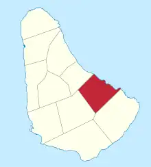 Map of Barbados showing the Saint John parish | |
| Coordinates: 13°10′N 59°29′W | |
| Country | Barbados |
| Largest city | Four Roads |
| Government | |
| • Type | Parliamentary democracy |
| • Parliamentary seats | 1 |
| Area | |
| • Total | 34 km2 (13 sq mi) |
| Population (2010 census) | |
| • Total | 8,963 |
| • Density | 260/km2 (680/sq mi) |
| ISO 3166 code | BB-05[1] |
References
- iso:code:3166:BB, International Organization for Standardization
This article is issued from Wikipedia. The text is licensed under Creative Commons - Attribution - Sharealike. Additional terms may apply for the media files.