Saint George, Barbados
The parish of Saint George ("St. George") is in the interior of Barbados. It is one of two land-locked parishes. The other is Saint Thomas to the north. A landmark in the parish is Gun Hill Signal Station. It is one of the few remaining signal stations, dating back to 1818.
Saint George | |
|---|---|
Parish | |
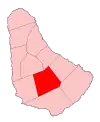 Map of Barbados showing Saint George | |
| Coordinates: =inline | |
| Country | Barbados |
| Independence | November 30, 1966 |
| Parliamentry seats | 2 |
| Government | |
| • Type | Parliamentary democracy |
| Area | |
| • Total | 44 km2 (17 sq mi) |
| Population (2008) | |
| • Total | 19,530 |
| • Density | 440/km2 (1,100/sq mi) |
| Time zone | UTC-4 (Eastern Caribbean) |
| Area code | |
| ccTLD | .bb |
| Largest town | The Glebe |
Saint George borders six of the eleven other parishes. This is more than any other parish.
This article is issued from Wikipedia. The text is licensed under Creative Commons - Attribution - Sharealike. Additional terms may apply for the media files.