Saarbrücken (district)
The Regionalverband Saarbrücken is a Kommunalverband besonderer Art, that is, it is a special mix of a rural district and a district free city. It is located in the south of the Saarland, Germany.
Saarbrücken | |
|---|---|
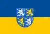 Flag 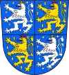 Coat of arms | |
 | |
| Country | Germany |
| State | Saarland |
| Capital | Saarbrücken |
| Area | |
| • Total | 410.62 km2 (158.54 sq mi) |
| Population (31 December 2022)[1] | |
| • Total | 330,848 |
| • Density | 810/km2 (2,100/sq mi) |
| Time zone | UTC+01:00 (CET) |
| • Summer (DST) | UTC+02:00 (CEST) |
| Vehicle registration | SB (Völklingen: VK) |
| Website | regionalverband-saarbruecken.de |
History
The district Saarbrücken was originally created in 1816. In 1974 the district and the district-free city Saarbrücken were merged, and the new administrative body was named Stadtverband Saarbrücken. Although it's not a district like others, most of its administrative tasks are same as those of a district.
Geography
The Saar River flows through the district, through the city Saarbrücken in the centre of the district.
Coat of arms
|
The original district had no coat of arms, the Regionalverband uses a coat derived from the one of the Counts of Nassau-Saarbrücken. The silver lion is taken from the County of Saarbrücken, the golden lion is the lion of Nassau. |
Towns and municipalities
| Towns | Municipalities |
|---|---|
|
|
References
- "Fläche und Bevölkerung - Stand: 31.12.2022 (Basis Zensus 2011)" (PDF) (in German). Statistisches Amt des Saarlandes. June 2023.
This article is issued from Wikipedia. The text is licensed under Creative Commons - Attribution - Sharealike. Additional terms may apply for the media files.