Ristolas
Ristolas is a former commune in the Hautes-Alpes department and Provence-Alpes-Côte d'Azur region in southeastern France. It is now part of Abriès-Ristolas.
Ristolas | |
|---|---|
Part of Abriès-Ristolas | |
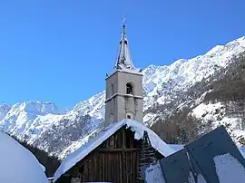 The church of Ristolas | |
 Coat of arms | |
Location of Ristolas | |
 Ristolas 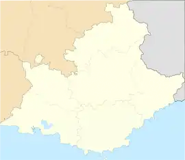 Ristolas | |
| Coordinates: 44°46′29″N 6°57′23″E | |
| Country | France |
| Region | Provence-Alpes-Côte d'Azur |
| Department | Hautes-Alpes |
| Arrondissement | Briançon |
| Canton | Guillestre |
| Commune | Abriès-Ristolas |
| Area 1 | 82.18 km2 (31.73 sq mi) |
| Population (2017)[1] | 86 |
| • Density | 1.0/km2 (2.7/sq mi) |
| Time zone | UTC+01:00 (CET) |
| • Summer (DST) | UTC+02:00 (CEST) |
| Postal code | 05460 |
| Elevation | 1,571–3,294 m (5,154–10,807 ft) (avg. 1,610 m or 5,280 ft) |
| 1 French Land Register data, which excludes lakes, ponds, glaciers > 1 km2 (0.386 sq mi or 247 acres) and river estuaries. | |
Geography
Ristolas is in the Cottian Alps. The Guil river passes through the village.
Transport
Road
The D947 and D947T roads pass through Ristolas.
Population
| Year | Pop. | ±% |
|---|---|---|
| 2006 | 91 | — |
| 2007 | 93 | +2.2% |
| 2008 | 96 | +3.2% |
| 2009 | 96 | +0.0% |
| 2010 | 90 | −6.2% |
| 2011 | 80 | −11.1% |
| 2012 | 71 | −11.3% |
| 2013 | 69 | −2.8% |
| 2014 | 68 | −1.4% |
| 2015 | 73 | +7.4% |
| 2016 | 80 | +9.6% |
This article is issued from Wikipedia. The text is licensed under Creative Commons - Attribution - Sharealike. Additional terms may apply for the media files.