Province of L'Aquila
The province of L'Aquila (Italian: provincia dell'Aquila) is a province in the Abruzzo region of Southern Italy. Its capital is the city of L'Aquila.
Province of L'Aquila | |
|---|---|
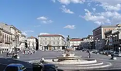 Piazza del Duomo at L'Aquila. | |
 Flag  Coat of arms | |
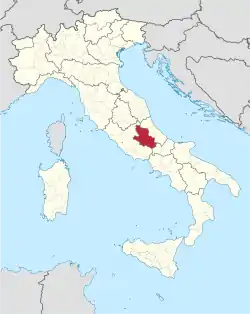 Map with the province of L'Aquila, in red, in Italy | |
| Coordinates: 42°21′58″N 13°23′40″E | |
| Country | |
| Region | Abruzzo |
| Capital | L'Aquila |
| Comuni | 108 |
| Government | |
| • President | Angelo Caruso[1] |
| Area | |
| • Total | 5,047.55 km2 (1,948.87 sq mi) |
| Population (January 2017)[3] | |
| • Total | 301,910 |
| • Density | 60/km2 (150/sq mi) |
| Time zone | UTC+1 (CET) |
| • Summer (DST) | UTC+2 (CEST) |
| Postal code | 67100, 67010, 67012-67015, 67017, 67019-67041, 67043-67064, 67066-67069 |
| Telephone prefix | 0862, 0863, 0864 |
| ISO 3166 code | IT-AQ |
| Vehicle registration | AQ |
| ISTAT | 066 |
| Website | Official website |
It is the largest province of the region but the one with fewest people living in it; it is a landlocked province, that is, surrounded by other provinces by all sides.
Geography
L'Aquila is the largest province in the Abruzzo region. It is almost half of the area of the region: it has area of 5,047.55 km2 (1,949 sq mi).[2] The province is bordered on the north by Tuscany, to the northeast by the province of Teramo, to the east by the Pescara and Province of Chieti provinces, to the south and southeast with the Molise region (province of Isernia), and to the west and southwest by the Lazio region (province of Frosinone, Rome and province of Rieti).
Places next to Province of L'Aquila | |
|---|---|
The main river in the province is the Aterno-Pescara river, known here as Aterno; it starts in the Monti della Laga and flows through the province.
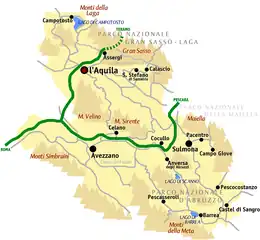
L'Aquila is the province of the Abruzzo region with more mountains; there are three mountain ranges that go from the northwest to the southeast, and that are parallels to the coastline: Monti della Gaga, Gran Sasso and Majella massif. The highest mountain in the province is Monte Amaro,(42°5′11″N 14°5′9″E) in the Majella massif, Apennines; it is 2,793 m (9,163 ft) high and is the highest mountain of three provinces: Chieti, L'Aquila and Pescara of the Abruzzo.[4]
Population
There are 301,910 persons living in the province (January 2017),[3] for a population density of 245.4 inhabitants/km². This population has been more or less stable for a long time.
The largest comune is L'Aquila, with 473.91 km2 (183 sq mi) and the smallest is Villa Sant'Angelo, with 5.22 km2 (2 sq mi). The comune with fewest people living in it is Carapelle Calvisio with 88 inhabitants.
Main comuni
The following table shows the 10 comuni with more inhabitants with their population,[3] and their area and altitude.[5]
| No. | Comune | Population (2017) | Area (km²) | Density | Altitude (m) |
|---|---|---|---|---|---|
| 1 | L'Aquila | 69,605 | 473.91 | 146.9 | 714 |
| 2 | Avezzano | 42,509 | 104.09 | 408.4 | 695 |
| 3 | Sulmona | 24,454 | 57.93 | 422.1 | 405 |
| 4 | Celano | 10,982 | 82.80 | 132.6 | 800 |
| 5 | Pratola Peligna | 7,553 | 28.67 | 263.4 | 342 |
| 6 | Tagliacozzo | 6,814 | 87.46 | 77.9 | 740 |
| 7 | Castel di Sangro | 6,634 | 84.44 | 78.6 | 793 |
| 8 | Trasacco | 6,264 | 51.44 | 121.8 | 685 |
| 9 | Luco dei Marsi | 6,088 | 44.87 | 135.7 | 680 |
| 10 | Carsoli | 5,381 | 95.80 | 56.2 | 616 |
Gallery


 Santo Stefano di Sessanio.
.jpg.webp) Pacentro.
Pacentro.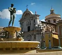 Piazza del Duomo, L'Aquila.
Related pages
- List of comuni of the Province of L'Aquila
References
- "Presidente" (in Italian). Provincia dell'Aquila. Archived from the original on 21 October 2017. Retrieved 16 November 2017.
- "Provincia dell'Aquila" (in Italian). Tuttitalia.it. Retrieved 16 November 2017.
- "Statistiche demografiche ISTAT" (in Italian). Demo.istat.it. Archived from the original on 3 January 2018. Retrieved 16 November 2017.
- "Monte Amaro, Italy". Peakbagger.com. Retrieved 16 November 2017.
- "Comuni in provincia dell'Aquila per popolazione" (in Italian). Tuttitalia.it. Retrieved 16 November 2017.
Other websites
- Province of L'Aquila official website (in Italian)