Plate tectonics
Plate tectonics is a theory of geology. It explains movement of the Earth's lithosphere. The lithosphere is the Earth's crust and the upper part of the mantle. The lithosphere is divided into plates, some of which are very large and can be entire continents.


Heat from the mantle is the source of energy driving plate tectonics. Exactly how this works is still a matter of debate. This theory includes the idea of continental drift.[1]
Earth's crust
The outermost part of the structure of the Earth is made up of two layers. The lithosphere, above, is solid. It includes the crust and the uppermost part of the mantle.
Below the lithosphere is the asthenosphere. The asthenosphere is like a solid or a hot viscous liquid. It can flow like a liquid on long time scales. Large convection currents in the asthenosphere transfer heat to the surface, where plumes of less dense magma break apart the plates at the spreading centers. The deeper mantle below the asthenosphere is more rigid again. This is caused by extremely high pressure.
Continental and oceanic plates
There are two types of tectonic plates: oceanic and continental.
An oceanic plate is a tectonic plate at the bottom of the oceans. It is primarily made of mafic rocks, rich in iron and magnesium. It is thinner than the continental crust (generally less than 10 kilometers thick) and denser. It is also younger than continental crust. When they collide, the oceanic plate moves underneath the continental plate because of its density. As a result, it melts in the mantle and reforms. The oldest oceanic rocks are less than 200 million years old.
Continental plate is the thick part of the earth's crust which forms the large land masses. Continental rock has lower density than oceanic rock. They are mostly made of felsic rocks. These have granite, with its abundant silica, aluminum, sodium and potassium. Continental plates are rarely destroyed. Their oldest rocks seem to be 4 billion years old. Oceanic plates cover about 71 percent of Earth’s surface, while continental plates cover 29 percent.
Thickness of plates
Ocean lithosphere varies in thickness. Because it is formed at mid-ocean ridges and spreads outward, it gets thicker as it moves further away from the mid-ocean ridge. Typically, the thickness varies from about 6 kilometres (3.7 mi) thick at mid-ocean ridges to greater than 100 kilometres (62 mi) at subduction zones.[1]
Continental lithosphere is about 200 kilometres (120 mi) thick. It varies between basins, mountain ranges, and the stable cratonic interiors of continents. The two types of crust differ in thickness, with continental crust being much thicker than oceanic: 35 kilometres (22 mi) vs. 6 kilometres (3.7 mi).[1]

Movement of plates
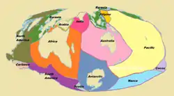
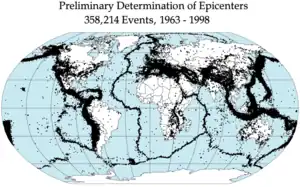
The lithosphere consists of tectonic plates. There are seven major and many minor plates. The lithospheric plates ride on the asthenosphere (aesthenosphere). The plate boundary is where two plates meet. When movement occurs, the plates may create mountains, earthquakes, volcanoes, mid-oceanic ridges and oceanic trenches, depending on which way the plates are moving.[3][4][5][6][7]
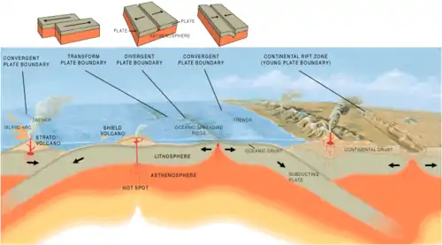
- Convergent boundaries: two plates move toward each other. Sometimes one plate will move under the other. This is called subduction. When an oceanic plate collides with a continental plate, the oceanic plate will move underneath the continental because it is denser. Convergent boundaries can create mountains and volcanoes. The Andes mountain range in South America and the Japanese island arc are examples, along with the Pacific Ring of Fire.
- Divergent boundaries: two plates move apart. As shown in the diagram, the place where the boundary occurs is called a rift. Magma from the mantle pushes up and cools off forming new land. They create earthquakes and trenches. The Mid-ocean ridges and Africa's Great Rift Valley are examples.
- Transform fault boundaries: two plates move side to side. They make earthquakes. The San Andreas Fault in California is an example of a transform boundary. New Zealand is another, more complex, example.
Earthquakes, volcanic activity, mountain-building, and oceanic trench formation occur along plate boundaries. The lateral movement of the plates varies from:
Major plates
Depending on how they are defined, seven or eight major plates are usually listed:
- African plate
- Antarctic plate
- Indo-Australian plate, sometimes subdivided into:
- Eurasian plate
- North American plate
- South American plate
- Pacific plate
Related pages
References
- Turcotte, D.L.; Schubert, G. (2002). "Plate Tectonics". Geodynamics (2 ed.). Cambridge University Press. pp. 1–21. ISBN 0-521-66186-2.
- Merdith, Andrew (16 December 2020). "Plate tectonics, Rodinia, Gondwana, supercontinent cycle". Plate model for 'Extending Full-Plate Tectonic Models into Deep Time: Linking the Neoproterozoic and the Phanerozoic'. doi:10.5281/zenodo.4485738. Retrieved 23 September 2022.
- Rolf Meissner 2002. The little book of planet Earth. New York: Copernicus Books. p202 ISBN 978-0-387-95258-1.
- "Plate Tectonics: Plate boundaries". platetectonics.com. Archived from the original on 16 June 2010. Retrieved 12 June 2010.
- Tackley, Paul J. (2000-06-16). "Mantle convection and plate tectonics: towards an integrated physical and chemical theory". Science. 288 (5473): 2002–2007. Bibcode:2000Sci...288.2002T. doi:10.1126/science.288.5473.2002. PMID 10856206.
- Seyfert, Carl K. (1987). The encyclopedia of structural geology and plate tectonics. ISBN 9780442281250.
- Oreskes, Naomi ed. 2003. Plate tectonics: an insider's history of the modern theory of the Earth. Westview Press ISBN 0-8133-4132-9
- Huang Zhen Shao (1997). "Speed of the continental plates". The physics factbook.
- Hancock, Paul L; Skinner, Brian J; Dineley, David L (2000). The Oxford Companion to the Earth. Oxford University Press. ISBN 0198540396.
- McKnight, Tom 2004. Geographica: the complete illustrated atlas of the world, Barnes and Noble; New York. ISBN 0-7607-5974-X
- Stanley, Steven M. 1999. Earth system history. Freeman, p211–228. ISBN 0-7167-2882-6
- Thompson, Graham R. & Turk, Jonathan 1991. Modern physical geology. Saunders. ISBN 0-03-025398-5
- Turcotte D.L. & Schubert G. 2002. Geodynamics. 2nd ed, Wiley, New York. ISBN 0-521-66624-4
Other websites
- Movie showing 750 million years of global tectonic activity.
- More movies over smaller regions and smaller time scales.
- Easy-to-draw illustrations for teaching plate tectonics
- Map of tectonic plates Archived 2017-01-12 at the Wayback Machine
- Plate tectonics -Citizendium