Passaic River
The Passaic River (/pəˈseɪ.ɪk/ pə-SAY-ik) is a river, about 80 mi (129 km) long,[1] in northern New Jersey in the United States.
| Passaic River | |
|---|---|
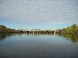
 Passaic River in Bergen and Passaic Counties | |
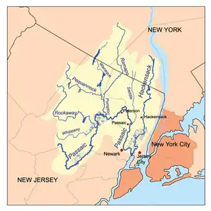
 The Passaic and Hackensack watersheds | |
| Location | |
| Country | United States |
| State | New Jersey |
| Counties | Hudson, Essex, Bergen, Passaic, Morris, Union, Somerset |
| District | Northern New Jersey, Gateway, Skylands |
| Cities | Newark, Paterson, Passaic |
| Physical characteristics | |
| Source | Unnamed Pond |
| - location | Mendham |
| - coordinates | 40°45′44″N 74°34′39″W |
| - elevation | 540 ft (160 m) |
| Mouth | Newark Bay |
| - location | Newark |
| - coordinates | 40°42′46″N 74°07′08″W |
| - elevation | 0 ft (0 m) |
| Length | 80 mi (130 km) |
| Basin size | 935 sq mi (2,420 km2) |
| Discharge | |
| - location | Little Falls |
| - average | 2,100 cu ft/s (59 m3/s) |
| - minimum | 36 cu ft/s (1.0 m3/s) |
| - maximum | 8,330 cu ft/s (236 m3/s) |
| Discharge | |
| - location | Chatham |
| - average | 320 cu ft/s (9.1 m3/s) |
| Basin features | |
| Tributaries | |
| - left | Rockaway River, Pompton River, Saddle River |
| - right | Dead River |
References
- PassaicRiver.com. "About the River." Accessed 2010-02-16. Archived October 10, 2008, at the Wayback Machine
This article is issued from Wikipedia. The text is licensed under Creative Commons - Attribution - Sharealike. Additional terms may apply for the media files.