Ontario Highway 17
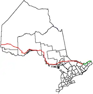
Ontario Highway 17 is a provincial highway in Ontario, Canada. It is 1,964 kilometres (1,220 miles) long.[2] This makes it Ontario's longest highway. It starts on the border with Manitoba, near Kenora. It ends near Arnprior where the highway merges with Ontario Highway 417.
Highway 17 | ||||
|---|---|---|---|---|
| Trans-Canada Highway | ||||
 | ||||
| Route information | ||||
| Maintained by Ministry of Transportation of Ontario | ||||
| Length | 1,964.0 km (1,220.4 mi) | |||
| Existed | February 26, 1920[1]–present | |||
| Tourist routes | ||||
| Major junctions | ||||
| West end | ||||
| East end | ||||
| Location | ||||
| Country | Canada | |||
| Province | Ontario | |||
| Major cities | Kenora, Dryden, Ignace, Thunder Bay, Wawa, Sault Ste. Marie, Sudbury, North Bay, Mattawa, Petawawa, Pembroke, Arnprior | |||
| Highway system | ||||
| ||||
| ||||


Highway 17 forms the Ontario part of the Trans-Canada Highway.[3]
Sources
- Shragge 1982, pp. 74–75.
- "The King's Highway 17". Cameron Bevers. Retrieved 4 January 2015.
- "Ontario #17 Highway Guide". Mile By Mile Media of British Columbia, Canada. Archived from the original on 23 July 2014. Retrieved 4 January 2015.
This article is issued from Wikipedia. The text is licensed under Creative Commons - Attribution - Sharealike. Additional terms may apply for the media files.