Morioka
Morioka (盛岡市, Morioka-shi) is a city in the Tōhoku region of Japan on the island of Honshu. It is the capital city of Iwate Prefecture.[1]
Morioka
盛岡 | |
|---|---|
| 盛岡市 · Morioka City | |
 Flag  Emblem | |
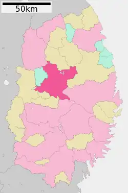 Location of Morioka in Iwate prefecture | |
 Morioka Location in Japan | |
| Coordinates: 39°42′7.5″N 141°09′16.2″E | |
| Country | Japan |
| Region | Tōhoku |
| Prefecture | Iwate prefecture |
| Government | |
| • Mayor | Hiroaki Tanifuji |
| Area | |
| • Total | 886.47 km2 (342.27 sq mi) |
| Population (2005) | |
| • Total | 300,740 |
| • Density | 588/km2 (1,520/sq mi) |
| Symbols | |
| • Tree | Katsura |
| • Flower | Rabbitear iris |
| Time zone | UTC+9 (Japan Standard Time) |
| City hall address | 12-2 Uchimaru, Morioka-shi 020-8530 |
| Website | www.city.morioka.iwate.jp |
It has been recognized as a core city since 2008.[2]
History
In the 9th century, Sakanoue no Tamuramaro led forces which brought the region under imperial control.
In 1599, Morioka was founded as a castle town (jōka-machi).
In the Boshin War, Morioka was a pro-shogunate city.
During the 2011 Tōhoku earthquake, Morioka was hit by a 6.1 earthquake.[3]
Culture
The Iwate Museum of Art (IMA) is in Morioka. IMA's collection includes works works by notable local artists.[4]
References
- Nussbaum, Louis-Frédéric. (2005). "Morioka" in Japan Encyclopedia, p. 661; "Tōhoku" at p. 970.
- Jacobs, A.J. "Japan's Evolving Nested Municipal Hierarchy: The Race for Local Power in the 2000s," Urban Studies Research, Vol. 2011 (2011), p. 8 [PDF 8 of 14]; retrieved 2012-12-5.
- MarketWatch.com, "New 6.1 magnitude quake hits near Morioka, Japan," March 11, 2011; retrieved 2012-8-31.
- Iwate Museum of Art (IMA), "Message from the Director" Archived 2012-06-17 at the Wayback Machine; retrieved 2012-8-31.
Other websites
![]() Media related to Morioka, Iwate at Wikimedia Commons
Media related to Morioka, Iwate at Wikimedia Commons
| Cities | Hachimantai | Hanamaki | Ichinoseki | Kamaishi | Kitakami | Kuji | Miyako | Morioka (capital) | Ninohe | Ōfunato | Ōshū | Rikuzentakata | Tōno | |
|---|---|---|
| Districts | Higashiiwai | Isawa | Iwate | Kamihei | Kesen | Kunohe | Ninohe | Nishiiwai | Shimohei | Shiwa | Waga | |
See also: Towns and villages by district | ||
This article is issued from Wikipedia. The text is licensed under Creative Commons - Attribution - Sharealike. Additional terms may apply for the media files.