Metro Vancouver
Metro Vancouver is a regional district in British Columbia, Canada. It was created in 1966. For 40 years it was called "The Greater Vancouver Regional District", but now it is called "Metro Vancouver".[1]
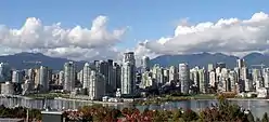
Downtown Vancouver.
The regional district includes 22 municipalities, one electoral area and one treaty First Nation.[2] The district covers 2,877.36 square kilometres (1,111 square miles). Metro Vancouver administers several services common to the local government units, such as utilities.
About half of households in Metro Vancouver live in strata-titled properties.[3]
Membership

With 631,486 residents recorded in the 2016 census, Vancouver is the most populated city in Metro Vancouver.
.jpg.webp)
With a population of 517,887 (2016), Surrey is the second-most populated city in Metro Vancouver.

Burnaby is the third-most populated city in Metro Vancouver with a population of 232,755 (2016).
This regional district comprises 23 local authorities as members: 21 municipalities, one electoral area and one treaty First Nation.[4]
| Metro Vancouver members | ||||
|---|---|---|---|---|
| Member[4] | Census subdivision type[5] | 2016 population[5] | 2011 population | Growth Rate
2011-2016 |
| Vancouver | City | 631,486 | 603,502 | 4.64% |
| Surrey | City | 517,887 | 468,251 | 10.60% |
| Burnaby | City | 232,755 | 223,218 | 4.27% |
| Richmond | City | 198,309 | 190,473 | 4.11% |
| Coquitlam | City | 139,284 | 126,804 | 9.84% |
| Langley | District municipality | 117,285 | 104,177 | 12.58% |
| Delta | City | 102,238 | 99,863 | 2.38% |
| North Vancouver | District municipality | 85,935 | 84,412 | 1.80% |
| Maple Ridge | City | 82,256 | 76,052 | 8.16% |
| New Westminster | City | 70,996 | 65,976 | 7.61% |
| Port Coquitlam | City | 58,612 | 55,958 | 4.74% |
| North Vancouver | City | 52,898 | 48,196 | 9.76% |
| West Vancouver | District municipality | 42,473 | 42,694 | -0.52% |
| Port Moody | City | 33,551 | 33,011 | 1.64% |
| Langley | City | 25,888 | 25,081 | 3.22% |
| White Rock | City | 19,952 | 19,339 | 3.17% |
| Pitt Meadows | City | 18,573 | 17,736 | 4.72% |
| Electoral Area A | Regional district electoral area | 16,133 | 12,988 | 24.21% |
| Bowen Island | Island municipality | 3,680 | 3,402 | 8.17% |
| Anmore | Village | 2,210 | 2,092 | 5.64% |
| Lions Bay | Village | 1,334 | 1,318 | 1.21% |
| Tsawwassen | Indian reserve (Treaty First Nation) | 816 | 720 | 13.33% |
| Belcarra | Village | 643 | 644 | -0.16% |
| Total Metro Vancouver Regional District | 2,463,431 | 2,313,328 | 6.49% | |
References
- Vancouver Sun (2 August 2007). "Goodbye GVRD, hello Metro Vancouver". CanWest MediaWorks Publications Inc. Archived from the original on 29 September 2007. Retrieved 27 July 2014.
- Kelly Sinoski (13 May 2014). "Judge's ruling upholds Langley rezoning plans". CanWest MediaWorks Publications Inc. Archived from the original on 3 July 2018. Retrieved 27 July 2014.
- "B.C. Stratas on edge after reports of soaring insurance premiums".
- "Member Municipalities". Metro Vancouver. Retrieved 19 February 2017.
- "Population and dwelling counts, for Canada, provinces and territories, and census subdivisions (municipalities), 2016 and 2011 censuses – 100% data (British Columbia)". Statistics Canada. 8 February 2017. Retrieved 19 February 2017.
This article is issued from Wikipedia. The text is licensed under Creative Commons - Attribution - Sharealike. Additional terms may apply for the media files.