Makati
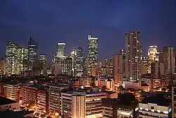
Makati, officially known as the City of Makati (/məˈkɑːtɪ/ mə-KAH-tee; Tagalog: Makati), in the Philippines, is one of the sixteen cities that make up Metro Manila. Makati is the financial center of the Philippines. As the host of various embassies, it is also an important center for international affairs.
Makati City
Lungsod ng Makati | |
|---|---|
City | |
| City of Makati | |
 The Makati skyline | |
| Nickname(s): The Financial Capital of the Philippines, the Wall Street of the Phils. | |
| Motto(s): Makati, Mahalin Natin, Atin Ito | |
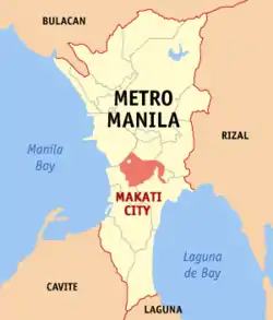
 Map of Metro Manila highlighting Makati City | |
| Country | Philippines |
| Region | National Capital |
| Districts | 1st and 2nd districts of Makati City |
| Settled | 1670 |
| Cityhood | January 2, 1995 |
| Barangays | 33 |
| Government | |
| • Type | Mayor–council government |
| • Mayor | Abigail Binay (UNA) |
| • Vice Mayor | Monique Lagdameo (UNA) |
| • Makati City Council | Councilors |
| Area | |
| • Total | 21.57 km2 (8.33 sq mi) |
| Elevation | 15.4 m (50.5 ft) |
| Population (2010)[2] | |
| • Total | 529,039 |
| • Density | 24,527/km2 (63,520/sq mi) |
| Time zone | UTC+8 (PST) |
| ZIP Code | 1200 to 1299 |
| Dialing code | 2 |
| Website | www |
With 529,039 people, Makati is the 16th-largest city in the country and ranked as the 41st most densely populated city in the world with 19,336 inhabitants per square kilometer.
Makati became the financial center of the Philippines during the 1960s. It is home to the Philippine Stock Exchange and the Makati Business Club.[3][4]
Makati is notable for its exceptionally multicultural lifestyle, as a significant center for intercontinental matters and for its reputation as a major entertainment center in the metropolis.[5] The city is also known for its cosmopolitan culture because of its major shopping centers, condominiums, financial hubs, hotels, and entertainment hubs, which are located around the city.[6]
Makati first became as the financial center of the Philippines during the 1960s. The Philippine Stock Exchange and the Makati Business Club are there.[7][8]
Barangays
Makati has divided into 33 barangays.
| Barangay | Population (2004) | Population (2010)[9] | Area (km2) | District |
|---|---|---|---|---|
| Bangkal | 22,433 | 23,378 | 0.74 | 1st |
| Bel-Air | 9,330 | 18,280 | 1.71 | 1st |
| Carmona | 3,699 | 3,096 | 0.34 | 1st |
| Cembo | 25,815 | 27,998 | 0.22 | 2nd |
| Comembo | 14,174 | 14,433 | 0.27 | 2nd |
| Dasmariñas | 5,757 | 5,654 | 1.90 | 1st |
| East Rembo | 23,902 | 26,433 | 0.44 | 2nd |
| Forbes Park | 3,420 | 2,533 | 2.53 | 1st |
| Guadalupe Nuevo | 22,493 | 18,271 | 0.57 | 2nd |
| Guadalupe Viejo | 13,632 | 16,411 | 0.62 | 2nd |
| Kasilawan | 6,224 | 5,291 | 0.09 | 1st |
| La Paz | 8,843 | 7,931 | 0.32 | 1st |
| Magallanes | 7,509 | 5,576 | 1.20 | 1st |
| Olympia | 20,172 | 21,270 | 0.44 | 1st |
| Palanan | 16,614 | 17,283 | 0.65 | 1st |
| Pembo | 35,035 | 44,803 | 1.23 | 2nd |
| Pinagkaisahan | 6,186 | 5,804 | 0.16 | 2nd |
| Pio del Pilar | 22,495 | 27,035 | 1.20 | 1st |
| Pitogo | 13,367 | 15,332 | 0.14 | 2nd |
| Poblacion | 8,446 | 17,120 | 0.46 | 1st |
| Rizal | 37,022 | 41,959 | 3.55 | 2nd |
| San Antonio | 12,226 | 11,443 | 0.89 | 1st |
| San Isidro | 8,686 | 7,589 | 0.50 | 1st |
| San Lorenzo | 6,487 | 10,006 | 2.09 | 1st |
| Santa Cruz | 7,419 | 7,440 | 0.47 | 1st |
| Singkamas | 6,226 | 7,426 | 0.13 | 1st |
| South Cembo | 13,570 | 14,672 | 0.20 | 2nd |
| Tejeros | 16,820 | 13,868 | 0.29 | 1st |
| Urdaneta | 3,817 | 3,717 | 0.74 | 1st |
| Valenzuela | 5,908 | 7,261 | 0.24 | 1st |
| West Rembo | 28,889 | 28,406 | 0.55 | 2nd |
References
- "Province: NCR, FOURTH DISTRICT". PSGC Interactive. Makati City, Philippines: National Statistical Coordination Board. Archived from the original on 14 November 2015. Retrieved 30 November 2012.
- "2010 Census of Population and Housing: National Capital Region" (PDF). National Statistics Office of the Republic of the Philippines. Archived from the original (PDF) on 15 November 2012. Retrieved 12 June 2012.
- "Archived copy". Archived from the original on 2016-03-03. Retrieved 2019-05-21.
{{cite web}}: CS1 maint: archived copy as title (link) - "Makati Business Club - non-profit business association - business forum Philippines".
- "About Makati, Philippines". www.makaticity.com.
- "Site Maintenance". www.touristcenter.com.ph.
- "Philippine Stock Exchange – Ayala Tower 1". Where in Manila. Archived from the original on 15 June 2013. Retrieved 10 March 2013.
- "About Us". Makati Business Club. Archived from the original on 17 March 2013. Retrieved 10 March 2013.
- "2010 Census of Population and Housing: National Capital Region" (PDF). National Statistics Office of the Republic of the Philippines. Archived from the original (PDF) on 15 November 2012. Retrieved 12 June 2012.