Lofa County
Lofa County is a county in Liberia.
Lofa County | |
|---|---|
County | |
 Flag | |
| Nickname: Tambah Nyumah | |
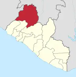 Location in Liberia | |
| Coordinates: 7°55′N 10°0′W | |
| Country | Liberia |
| Capital | Voinjama |
| Districts | 6 |
| Established | 1964 |
| Area | |
| • Total | 9,982 km2 (3,854 sq mi) |
| Population (2008) | |
| • Total | 270,114 |
| • Density | 27.1/km2 (70/sq mi) |
| Time zone | UTC+0 (GMT) |
The county is bordered by Bong County to the south and Gbarpolu County to the west. The northwestern parts of Lofa border the nation of Sierra Leone. The northeastern parts border Guinea. Mount Wuteve, the highest mountain in Liberia, is in the county.
This article is issued from Wikipedia. The text is licensed under Creative Commons - Attribution - Sharealike. Additional terms may apply for the media files.